Geographic Region: KYRGYZSTAN
Feature: LAKE ISSYKKUL
|
Geographic Region: KYRGYZSTAN Feature: LAKE ISSYKKUL |
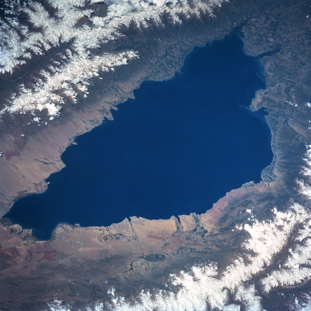 |
| STS091-715-005 Issyk-Kul, Kyrgystan June 1998 Located in northeast Kyrgyzstan, Issyk-Kul is one of the deepest mountain lakes in the world with a maximum depth of 2303 feet (702 meters). Named for the "warm water" that the lake contains, this slightly brackish lake never freezes. Issyk-Kul could be called "Mile High Lake" since the surface of the lake is 5280 feet (1609 meters) above sea level. The lake is 115 miles (185 km) in length and 38 miles (61 km) at its widest point. The basin that the lake sits in is the result of a block of the earth's crust that subsided between two faults, known as a graben. Eroded debris (lighter-colored landscape) from the elevated mountain slopes is more recognizable around the western end of the lake and the darker terrain around the eastern end of the lake shows cultivated field patterns (mainly wheat fields). The north and south shorelines around the lake were once part of the Great Silk Road that connected China with the Middle East and parts of Russia. Although the region is semi-arid, snowmelt (runoff) from the surrounding mountains (seen here as snow capped mountains) provides sufficient fresh water to allow dry land farming on the flatter plains within the valleys. Mountain ranges north (Kiungey-Ala-Too) and south (Terskey-Ala-Too) of the lake with peaks that range between 13000 feet (3962 meters) to 18000 feet (5486 meters) are part of the regional Tien Shan (mountains). |
| Images: | All Available Images Low-Resolution 368k |
|
| Mission: | STS091 |
|
| Roll - Frame: | 715 - 5 |
|
| Geographical Name: | KYRGYZSTAN |
|
| Features: | LAKE ISSYKKUL |
|
| Center Lat x Lon: | 42.5N x 77.5E |
|
| Film Exposure: | N | N=Normal exposure, U=Under exposed, O=Over exposed, F=out of Focus |
| Percentage of Cloud Cover-CLDP: | 10 |
|
| Camera:: | HB |
|
| Camera Tilt: | 54 | LO=Low Oblique, HO=High Oblique, NV=Near Vertical |
| Camera Focal Length: | 250 |
|
| Nadir to Photo Center Direction: | E | The direction from the nadir to the center point, N=North, S=South, E=East, W=West |
| Stereo?: | Y | Y=Yes there is an adjacent picture of the same area, N=No there isn't |
| Orbit Number: | 134 |
|
| Date: | 19980611 | YYYYMMDD |
| Time: | 094733 | GMT HHMMSS |
| Nadir Lat: | 41.3N |
Latitude of suborbital point of spacecraft |
| Nadir Lon: | 73.2E |
Longitude of suborbital point of spacecraft |
| Sun Azimuth: | 254 | Clockwise angle in degrees from north to the sun measured at the nadir point |
| Space Craft Altitude: | 196 | nautical miles |
| Sun Elevation: | 52 | Angle in degrees between the horizon and the sun, measured at the nadir point |
| Land Views: | MOUNTAIN, VALLEY |
|
| Water Views: | LAKE |
|
| Atmosphere Views: | |
|
| Man Made Views: | |
|
| City Views: | |
|
Photo is not associated with any sequences | ||
| NASA Home Page |
JSC Home Page |
JSC Digital Image Collection |
Earth Science & Remote Sensing |
|
This service is provided by the International Space Station program and the JSC Earth Science & Remote Sensing Unit, ARES Division, Exploration Integration Science Directorate.

|