
Geographic Region: TURKMENISTAN
Feature: SARYKAMYSHKOYE LAKE
|
Geographic Region: TURKMENISTAN Feature: SARYKAMYSHKOYE LAKE |
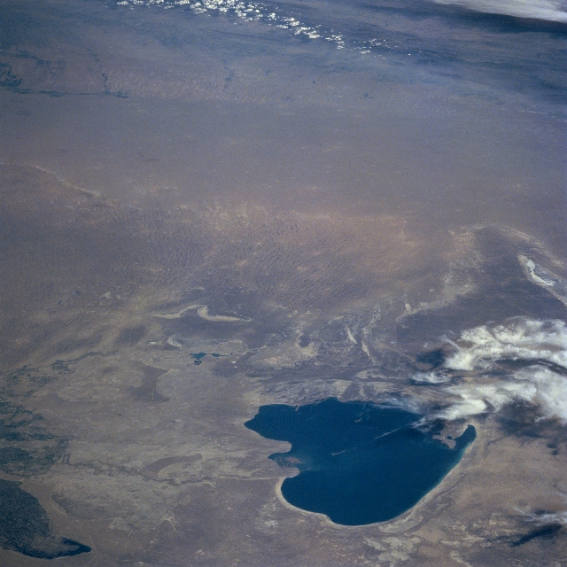 |
| STS091-714-056 Lake Sarygamysh, Turkmenistan June 1998 Looking south across Lake Sarygamysh (dark feature, bottom center), a broad expanse of desert landscape is visible. Lake Sarygamysh, situated in north central Turkmenistan, is geographically located midway between the Caspian Sea and the Aral Sea. This desert, known as the Garagum Desert, extends from the Ust-Urt Plateau (north of the lake) to the Kopet-Dag Mountains (upper right corner) in the south of Turkmenistan and from the Amu Darya River in the east and almost reaching the Caspian Sea to the west of the desert. The desert is characterized by relatively flat terrain with large areas of sand dunes and sand ridges (visible near center of the picture). The darker feature south of the lake (right middle) is a grassy elevated plain. The white areas immediately southwest of the lake (lower right corner) are clouds. Although the lake is filled with water at the time this photograph was acquired, some maps indicate that the lake is, at least partially, a dry lakebed from time to time. Approximately the northwest quarter of the lake belongs to the country of Uzbekistan. |
| Images: | All Available Images Low-Resolution 318k |
|
| Mission: | STS091 |
|
| Roll - Frame: | 714 - 56 |
|
| Geographical Name: | TURKMENISTAN |
|
| Features: | SARYKAMYSHKOYE LAKE |
|
| Center Lat x Lon: | 41.0N x 58.0E |
|
| Film Exposure: | N | N=Normal exposure, U=Under exposed, O=Over exposed, F=out of Focus |
| Percentage of Cloud Cover-CLDP: | 5 |
|
| Camera:: | HB |
|
| Camera Tilt: | LO | LO=Low Oblique, HO=High Oblique, NV=Near Vertical |
| Camera Focal Length: | 250 |
|
| Nadir to Photo Center Direction: | The direction from the nadir to the center point, N=North, S=South, E=East, W=West |
|
| Stereo?: | Y | Y=Yes there is an adjacent picture of the same area, N=No there isn't |
| Orbit Number: | |
|
| Date: | 199806__ | YYYYMMDD |
| Time: | GMT HHMMSS |
|
| Nadir Lat: | N |
Latitude of suborbital point of spacecraft |
| Nadir Lon: | E |
Longitude of suborbital point of spacecraft |
| Sun Azimuth: | Clockwise angle in degrees from north to the sun measured at the nadir point |
|
| Space Craft Altitude: | nautical miles |
|
| Sun Elevation: | Angle in degrees between the horizon and the sun, measured at the nadir point |
|
| Land Views: | DESERT, PLAIN |
|
| Water Views: | LAKE |
|
| Atmosphere Views: | |
|
| Man Made Views: | |
|
| City Views: | |
|
Photo is not associated with any sequences | ||
| NASA Home Page |
JSC Home Page |
JSC Digital Image Collection |
Earth Science & Remote Sensing |
|
This service is provided by the International Space Station program and the JSC Earth Science & Remote Sensing Unit, ARES Division, Exploration Integration Science Directorate.

|