
Geographic Region: ARGENTINA
Feature: SAN RAMON, RIO BLANCO
|
Geographic Region: ARGENTINA Feature: SAN RAMON, RIO BLANCO |
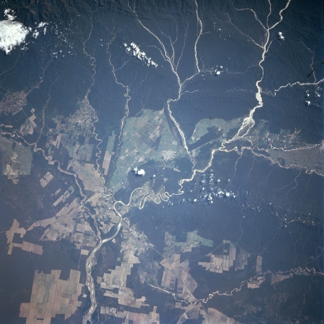 |
| STS091-708-004 Bermejo, Blanco Rivers, Argentina June 1998 New agricultural fields are seen in northwestern Argentina. The small city of San Ramon De La Nueva Oran is in the center of the image. The deforestation of this region of Argentina near the Bolivian border has increased since the mid 1980's. The 330 mile (531 km) long Blanco River, which rises in the Andes Mountains of southeast Bolivia, is just to the right of the top center of the view. The Blanco River flows generally eastward out of the Andes foothills and passes just to the north of San Ramon De La Nueva Oran where it joins the Bermejo River. The San Francisco River is in the left center of the image and flows generally northeast before joining the Bermejo River. A railroad and highway connect the city of San Ramon to cities further to the east. The city is a major commercial center for this region of Argentina. |
| Images: | All Available Images Low-Resolution 332k |
|
| Mission: | STS091 |
|
| Roll - Frame: | 708 - 4 |
|
| Geographical Name: | ARGENTINA |
|
| Features: | SAN RAMON, RIO BLANCO |
|
| Center Lat x Lon: | 23S x 64.5W |
|
| Film Exposure: | N | N=Normal exposure, U=Under exposed, O=Over exposed, F=out of Focus |
| Percentage of Cloud Cover-CLDP: | 5 |
|
| Camera:: | HB |
|
| Camera Tilt: | 28 | LO=Low Oblique, HO=High Oblique, NV=Near Vertical |
| Camera Focal Length: | 250 |
|
| Nadir to Photo Center Direction: | SW | The direction from the nadir to the center point, N=North, S=South, E=East, W=West |
| Stereo?: | Y | Y=Yes there is an adjacent picture of the same area, N=No there isn't |
| Orbit Number: | 44 |
|
| Date: | 19980605 | YYYYMMDD |
| Time: | 170211 | GMT HHMMSS |
| Nadir Lat: | 21.9S |
Latitude of suborbital point of spacecraft |
| Nadir Lon: | 63.1W |
Longitude of suborbital point of spacecraft |
| Sun Azimuth: | 344 | Clockwise angle in degrees from north to the sun measured at the nadir point |
| Space Craft Altitude: | 204 | nautical miles |
| Sun Elevation: | 44 | Angle in degrees between the horizon and the sun, measured at the nadir point |
| Land Views: | UPLAND, FOREST |
|
| Water Views: | RIVER |
|
| Atmosphere Views: | |
|
| Man Made Views: | AGRICULTURE, DEFORESTATION |
|
| City Views: | |
|
Photo is not associated with any sequences | ||
| NASA Home Page |
JSC Home Page |
JSC Digital Image Collection |
Earth Science & Remote Sensing |
|
This service is provided by the International Space Station program and the JSC Earth Science & Remote Sensing Unit, ARES Division, Exploration Integration Science Directorate.

|