
Geographic Region: BRAZIL
Feature: MTS.,R. PARAGUAI,CACERES
|
Geographic Region: BRAZIL Feature: MTS.,R. PARAGUAI,CACERES |
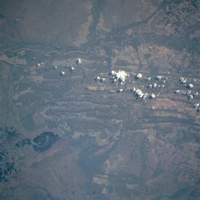 |
| STS091-708-014 Rio Paraguai, Mato Grosso State, Brazil June 1998 The Rio Paraguai (top of picture) is part of a very large wetland ecosystem that exhibits a remarkable biodiversity known as the Pantanal. The Pantanal is located in west central Brazil and eastern Bolivia. This vast expanse of poorly drained wetlands experiences annual inundation. The terrain west of the river is flat savanna and wetlands; while east of the river a series of low, parallel, folded ridgelines are visible. The lighter colored landscape with angular-looking field patterns appears to be used for a variety of agricultural purposes, including crop production and cattle ranching. Mining activities and timber operations also contribute to the economy in this region that is faced with serious environmental issues. The city of Caceres can be identified along the east bank of the Rio Paraguai near the upper right corner of the picture. An airport runway (short, light colored, straight line) is visible northeast of Caceres. The roughly oval-shaped feature (dark area) in the southeast quadrant appears to be a lake. |
| Images: | All Available Images Low-Resolution 303k |
|
| Mission: | STS091 |
|
| Roll - Frame: | 708 - 14 |
|
| Geographical Name: | BRAZIL |
|
| Features: | MTS.,R. PARAGUAI,CACERES |
|
| Center Lat x Lon: | 16.5S x 57.5W |
|
| Film Exposure: | N | N=Normal exposure, U=Under exposed, O=Over exposed, F=out of Focus |
| Percentage of Cloud Cover-CLDP: | 5 |
|
| Camera:: | HB |
|
| Camera Tilt: | 14 | LO=Low Oblique, HO=High Oblique, NV=Near Vertical |
| Camera Focal Length: | 250 |
|
| Nadir to Photo Center Direction: | SE | The direction from the nadir to the center point, N=North, S=South, E=East, W=West |
| Stereo?: | Y | Y=Yes there is an adjacent picture of the same area, N=No there isn't |
| Orbit Number: | 44 |
|
| Date: | 19980605 | YYYYMMDD |
| Time: | 170411 | GMT HHMMSS |
| Nadir Lat: | 16S |
Latitude of suborbital point of spacecraft |
| Nadir Lon: | 58.2W |
Longitude of suborbital point of spacecraft |
| Sun Azimuth: | 335 | Clockwise angle in degrees from north to the sun measured at the nadir point |
| Space Craft Altitude: | 203 | nautical miles |
| Sun Elevation: | 48 | Angle in degrees between the horizon and the sun, measured at the nadir point |
| Land Views: | FLOOD PLAIN, PLAIN, HILL |
|
| Water Views: | RIVER, SWAMP |
|
| Atmosphere Views: | |
|
| Man Made Views: | |
|
| City Views: | |
|
Photo is not associated with any sequences | ||
| NASA Home Page |
JSC Home Page |
JSC Digital Image Collection |
Earth Science & Remote Sensing |
|
This service is provided by the International Space Station program and the JSC Earth Science & Remote Sensing Unit, ARES Division, Exploration Integration Science Directorate.

|