
Geographic Region: USA-LOUISIANA
Feature: ATCHAFALAYA RIVER
|
Geographic Region: USA-LOUISIANA Feature: ATCHAFALAYA RIVER |
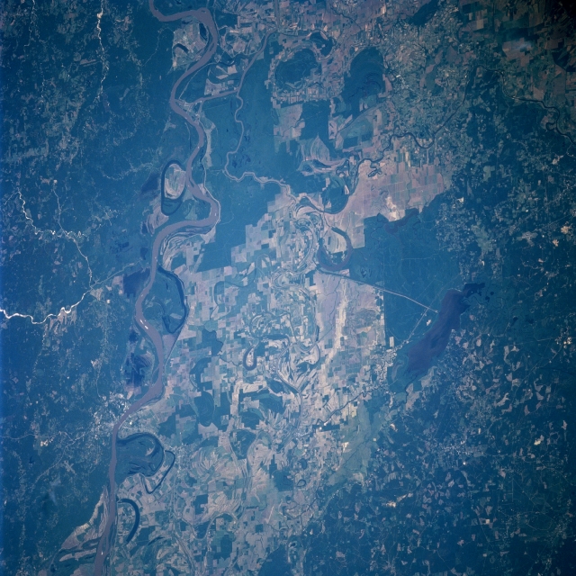 |
| STS091-707-017 Mississippi River and Floodplain, Louisiana, USA June 1998 The meander scars, including numerous oxbow lakes that have been created by the Mississippi River, are very evident on this easterly view of the broad floodplain of the Mississippi River. In the image the Mississippi River extends in a north-south direction from north of Natchez, MS to northeast of Baton Rouge, LA. Hydrologically the Mississippi floodplain is complicated by a canal that connects this river to the Atchafalaya River (near the southern edge of the picture), and also by the Red River (south of the crescent shaped oxbow lake near center) that merges with the Atchafalaya. The Black River parallels the Mississippi in this image. When the Black river from the north joins the Red River from the southwest it becomes the Atchafalaya River. Catahoyla Lake (elongated, dark feature) is connected to the Black River (narrow, meandering river with large loops at the center of the photograph) by a linear canal, northeast of a crescent shaped oxbow lake near the center of the image. Cultivated field patterns (multicolored, angular features) are visible on the fertile soils of the floodplain west of the main channel of the Mississippi River. Extensive wooded areas (darker landscapes) are observed immediately east of the Mississippi River and along the western edge of the picture. |
| Images: | All Available Images Low-Resolution 374k |
|
| Mission: | STS091 |
|
| Roll - Frame: | 707 - 17 |
|
| Geographical Name: | USA-LOUISIANA |
|
| Features: | ATCHAFALAYA RIVER |
|
| Center Lat x Lon: | 31.5N x 92W |
|
| Film Exposure: | N | N=Normal exposure, U=Under exposed, O=Over exposed, F=out of Focus |
| Percentage of Cloud Cover-CLDP: | 0 |
|
| Camera:: | HB |
|
| Camera Tilt: | 35 | LO=Low Oblique, HO=High Oblique, NV=Near Vertical |
| Camera Focal Length: | 250 |
|
| Nadir to Photo Center Direction: | E | The direction from the nadir to the center point, N=North, S=South, E=East, W=West |
| Stereo?: | Y | Y=Yes there is an adjacent picture of the same area, N=No there isn't |
| Orbit Number: | 79 |
|
| Date: | 19980607 | YYYYMMDD |
| Time: | 212717 | GMT HHMMSS |
| Nadir Lat: | 32.5N |
Latitude of suborbital point of spacecraft |
| Nadir Lon: | 94.1W |
Longitude of suborbital point of spacecraft |
| Sun Azimuth: | 270 | Clockwise angle in degrees from north to the sun measured at the nadir point |
| Space Craft Altitude: | 197 | nautical miles |
| Sun Elevation: | 47 | Angle in degrees between the horizon and the sun, measured at the nadir point |
| Land Views: | FLOOD PLAIN, FOREST |
|
| Water Views: | RIVER, SWAMP, LAKE |
|
| Atmosphere Views: | |
|
| Man Made Views: | |
|
| City Views: | |
|
Photo is not associated with any sequences | ||
| NASA Home Page |
JSC Home Page |
JSC Digital Image Collection |
Earth Science & Remote Sensing |
|
This service is provided by the International Space Station program and the JSC Earth Science & Remote Sensing Unit, ARES Division, Exploration Integration Science Directorate.

|