
Geographic Region: IRAN
Feature: NAMAKE SIRIAN DESERT
|
Geographic Region: IRAN Feature: NAMAKE SIRIAN DESERT |
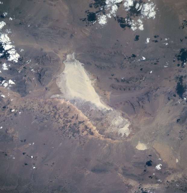 |
| STS091-704-082 Hamak-e-Sirtan Desert, Iran June 1998 The highly reflective dry lakebed (center of image) is part of the Namak-e-Sirtan Desert that is located in south central Iran. The southern end of the dry lakebed is flanked by rugged mountains where peaks exceed 8900 feet (2710 meters) in elevation. This arid valley only receives an average of 7 inches (180 mm) of precipitation annually. East of the dry lake the mottled-looking (alternating dark and light) landscape shows a limited area where dry land agriculture is possible. Towards the center of the agricultural activity Sirjan, a special economic free trade zone, is developing. The Sirjan area provides a natural overland corridor in the province of Kerman where ground transportation of commercial goods from the Persian Gulf can be distributed throughout Iran, as well as other countries of Asia. |
| Images: | All Available Images Low-Resolution 328k |
|
| Mission: | STS091 |
|
| Roll - Frame: | 704 - 82 |
|
| Geographical Name: | IRAN |
|
| Features: | NAMAKE SIRIAN DESERT |
|
| Center Lat x Lon: | 29.5N x 55.5E |
|
| Film Exposure: | N | N=Normal exposure, U=Under exposed, O=Over exposed, F=out of Focus |
| Percentage of Cloud Cover-CLDP: | 5 |
|
| Camera:: | HB |
|
| Camera Tilt: | 37 | LO=Low Oblique, HO=High Oblique, NV=Near Vertical |
| Camera Focal Length: | 250 |
|
| Nadir to Photo Center Direction: | N | The direction from the nadir to the center point, N=North, S=South, E=East, W=West |
| Stereo?: | N | Y=Yes there is an adjacent picture of the same area, N=No there isn't |
| Orbit Number: | 57 |
|
| Date: | 19980606 | YYYYMMDD |
| Time: | 114209 | GMT HHMMSS |
| Nadir Lat: | 27.2N |
Latitude of suborbital point of spacecraft |
| Nadir Lon: | 54.5E |
Longitude of suborbital point of spacecraft |
| Sun Azimuth: | 276 | Clockwise angle in degrees from north to the sun measured at the nadir point |
| Space Craft Altitude: | 198 | nautical miles |
| Sun Elevation: | 44 | Angle in degrees between the horizon and the sun, measured at the nadir point |
| Land Views: | DESERT, MOUNTAIN |
|
| Water Views: | PLAYA |
|
| Atmosphere Views: | |
|
| Man Made Views: | AGRICULTURE |
|
| City Views: | |
|
Photo is not associated with any sequences | ||
| NASA Home Page |
JSC Home Page |
JSC Digital Image Collection |
Earth Science & Remote Sensing |
|
This service is provided by the International Space Station program and the JSC Earth Science & Remote Sensing Unit, ARES Division, Exploration Integration Science Directorate.

|