
Geographic Region: MEXICO
Feature: SMOKE, COAST, MUERTO SEA
|
Geographic Region: MEXICO Feature: SMOKE, COAST, MUERTO SEA |
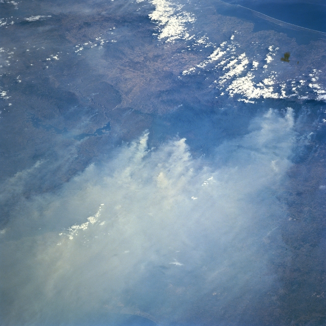 |
| STS091-701-074 Fires, Isthmus of Thuantepec, Mexico June 1998 Many of the extensive, land clearing fires and the resultant smoke on the forested slopes of the mountains in southern Mexico are seen in this southwest-looking view of the Isthumus of Tehuantepec. The two major features that help to identify the specific geographic area in this image are the dark, crescent-shaped feature with the irregular edges (Nezahualcayotl Reservoir--left center of image) and the dark Muerto Lagoon and the Gulf of Tehuantepec (upper right corner). The environmental impact of these fires at times reached as far north as the central plains of the United States. (Refer to STS91-713-024 for fires and smoke palls along the Bay of Campeche coast of Mexico). |
| Images: | All Available Images Low-Resolution 313k |
|
| Mission: | STS091 |
|
| Roll - Frame: | 701 - 74 |
|
| Geographical Name: | MEXICO |
|
| Features: | SMOKE, COAST, MUERTO SEA |
|
| Center Lat x Lon: | 16.5N x 94.5W |
|
| Film Exposure: | O | N=Normal exposure, U=Under exposed, O=Over exposed, F=out of Focus |
| Percentage of Cloud Cover-CLDP: | 15 |
|
| Camera:: | HB |
|
| Camera Tilt: | LO | LO=Low Oblique, HO=High Oblique, NV=Near Vertical |
| Camera Focal Length: | 250 |
|
| Nadir to Photo Center Direction: | SE | The direction from the nadir to the center point, N=North, S=South, E=East, W=West |
| Stereo?: | N | Y=Yes there is an adjacent picture of the same area, N=No there isn't |
| Orbit Number: | 17 |
|
| Date: | 19980603 | YYYYMMDD |
| Time: | 222409 | GMT HHMMSS |
| Nadir Lat: | 21.0N |
Latitude of suborbital point of spacecraft |
| Nadir Lon: | 96.8W |
Longitude of suborbital point of spacecraft |
| Sun Azimuth: | 283 | Clockwise angle in degrees from north to the sun measured at the nadir point |
| Space Craft Altitude: | 197 | nautical miles |
| Sun Elevation: | 35 | Angle in degrees between the horizon and the sun, measured at the nadir point |
| Land Views: | COAST |
|
| Water Views: | RESERVOIR, LAGOON |
|
| Atmosphere Views: | SMOKE |
|
| Man Made Views: | |
|
| City Views: | |
|
Photo is not associated with any sequences | ||
| NASA Home Page |
JSC Home Page |
JSC Digital Image Collection |
Earth Science & Remote Sensing |
|
This service is provided by the International Space Station program and the JSC Earth Science & Remote Sensing Unit, ARES Division, Exploration Integration Science Directorate.

|