
Geographic Region: USA-NEW MEXICO
Feature: REDONDO PEAK, RESERVOIRS
|
Geographic Region: USA-NEW MEXICO Feature: REDONDO PEAK, RESERVOIRS |
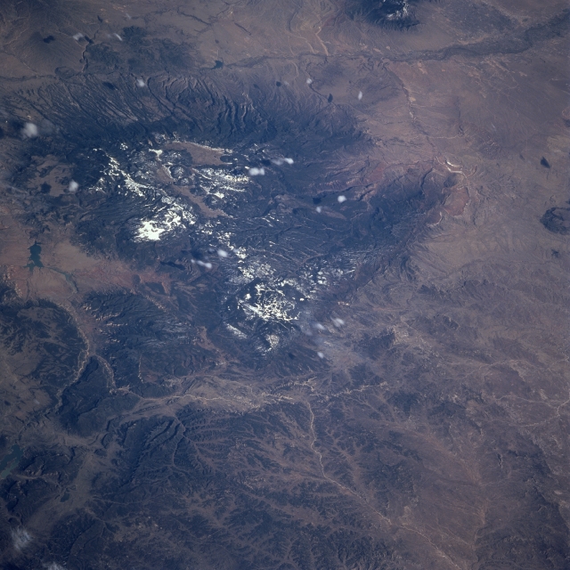 |
| STS090-755-075 Jemez Mountains, New Mexico, USA April 1998 Located in north central New Mexico about 50 miles (80 kilometers) north of Albuquerque is the Jemez Mountains. These mountains are a major volcanic landform and are the result of numerous volcanic eruptions that occurred in relatively recent geologic time (approximately 1 million years ago). Also known as Jemez Cladera and the Valles Caldera, this area is distinctive because of its circlet of lava domes located towards the northern rim. The Rio Chama and Abiquiu Reservoir border the mountains to the north and the Jemez River is visible along the southern flank of the mountains. Both of these rivers flow into the Rio Grande that follows the Rio Grande Rift that is visible in this image as the linear feature that parallels the bottom of the picture (along the east side of the mountains). The Nacimiento Fault is a prominent feature located along the western side of the Nacimiento Mountains (west of Jemez Mountains). A few puffy-looking cumulus clouds are visible. Most of the lighter-colored (highly reflective) areas show snow cover on the higher elevations of the mountains and in many of the shaded valleys. |
| Images: | All Available Images Low-Resolution 330k |
|
| Mission: | STS090 |
|
| Roll - Frame: | 755 - 75 |
|
| Geographical Name: | USA-NEW MEXICO |
|
| Features: | REDONDO PEAK, RESERVOIRS |
|
| Center Lat x Lon: | 36.0N x 107W |
|
| Film Exposure: | N | N=Normal exposure, U=Under exposed, O=Over exposed, F=out of Focus |
| Percentage of Cloud Cover-CLDP: | 5 |
|
| Camera:: | HB |
|
| Camera Tilt: | 53 | LO=Low Oblique, HO=High Oblique, NV=Near Vertical |
| Camera Focal Length: | 250 |
|
| Nadir to Photo Center Direction: | S | The direction from the nadir to the center point, N=North, S=South, E=East, W=West |
| Stereo?: | Y | Y=Yes there is an adjacent picture of the same area, N=No there isn't |
| Orbit Number: | 36 |
|
| Date: | 19980419 | YYYYMMDD |
| Time: | 225832 | GMT HHMMSS |
| Nadir Lat: | 38.8N |
Latitude of suborbital point of spacecraft |
| Nadir Lon: | 108.3W |
Longitude of suborbital point of spacecraft |
| Sun Azimuth: | 257 | Clockwise angle in degrees from north to the sun measured at the nadir point |
| Space Craft Altitude: | 140 | nautical miles |
| Sun Elevation: | 33 | Angle in degrees between the horizon and the sun, measured at the nadir point |
| Land Views: | MOUNTAIN, FAULT |
|
| Water Views: | RIVER, LAKE |
|
| Atmosphere Views: | |
|
| Man Made Views: | |
|
| City Views: | |
|
Photo is not associated with any sequences | ||
| NASA Home Page |
JSC Home Page |
JSC Digital Image Collection |
Earth Science & Remote Sensing |
|
This service is provided by the International Space Station program and the JSC Earth Science & Remote Sensing Unit, ARES Division, Exploration Integration Science Directorate.

|