
Geographic Region: USA-CALIFORNIA
Feature: OWENS LAKE
|
Geographic Region: USA-CALIFORNIA Feature: OWENS LAKE |
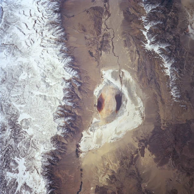 |
| STS090-755-047 Owens Dry Lake, California April 1998 Owens Lake, now a dry lakebed, can be seen in this view. The high snow-covered peaks of the Sierra Nevada are visible to the west of the dry lake and cover the top-third of the image. The rugged snow-capped Inyo Mountains can be seen to the east of the dry lake in the lower center and lower left of the image. Owens Lake formerly held waters 18 miles (29 km) long and 10 miles (16 km) wide. The lake was fed by the Owens River, seen traversing the image from north to south. The water from the river is now taken via the Los Angeles Aqueduct to the city of Los Angeles to supplement their drinking water. The dry lakebed is a source of dust storms in the western United States. |
| Images: | All Available Images Low-Resolution 359k |
|
| Mission: | STS090 |
|
| Roll - Frame: | 755 - 47 |
|
| Geographical Name: | USA-CALIFORNIA |
|
| Features: | OWENS LAKE |
|
| Center Lat x Lon: | 36.5N x 118W |
|
| Film Exposure: | N | N=Normal exposure, U=Under exposed, O=Over exposed, F=out of Focus |
| Percentage of Cloud Cover-CLDP: | 0 |
|
| Camera:: | HB |
|
| Camera Tilt: | 8 | LO=Low Oblique, HO=High Oblique, NV=Near Vertical |
| Camera Focal Length: | 250 |
|
| Nadir to Photo Center Direction: | W | The direction from the nadir to the center point, N=North, S=South, E=East, W=West |
| Stereo?: | N | Y=Yes there is an adjacent picture of the same area, N=No there isn't |
| Orbit Number: | 35 |
|
| Date: | 19980419 | YYYYMMDD |
| Time: | 212204 | GMT HHMMSS |
| Nadir Lat: | 36.6N |
Latitude of suborbital point of spacecraft |
| Nadir Lon: | 117.7W |
Longitude of suborbital point of spacecraft |
| Sun Azimuth: | 226 | Clockwise angle in degrees from north to the sun measured at the nadir point |
| Space Craft Altitude: | 137 | nautical miles |
| Sun Elevation: | 57 | Angle in degrees between the horizon and the sun, measured at the nadir point |
| Land Views: | MOUNTAIN, VALLEY |
|
| Water Views: | LAKE, RIVER |
|
| Atmosphere Views: | |
|
| Man Made Views: | |
|
| City Views: | |
|
Photo is not associated with any sequences | ||
| NASA Home Page |
JSC Home Page |
JSC Digital Image Collection |
Earth Science & Remote Sensing |
|
This service is provided by the International Space Station program and the JSC Earth Science & Remote Sensing Unit, ARES Division, Exploration Integration Science Directorate.

|