
Geographic Region: USA-FLORIDA
Feature: SOUTH FLORIDA, SUNGLINT
|
Geographic Region: USA-FLORIDA Feature: SOUTH FLORIDA, SUNGLINT |
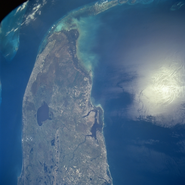 |
| STS090-754-079 Southern Florida, Florida, USA April 1998 The southern half of the Florida peninsula is visible from Cape Canaveral along the east coast to the Florida Keys. The synoptic nature of this view provides a unique opportunity to identify and locate the major geographic features in south Florida. These features include the densely populated southeast coast of Florida, including the greater Miami metropolitan area; the largely uninhabited Everglades at the south end of the Florida peninsula; the Fort Myers area (immediately south of the large bay on the west coast of the peninsula) and Lake Okeechobee (large dark feature northwest of the Miami area). The karst topography of central Florida is identified by numerous lakes (sink holes). These lakes are created by water reacting with the limestone rocks that underlay the Florida peninsula. The deep, blue water of the Gulf Stream is visible between Miami and Bimini Island in the Bahamas. The very bright spot off of the west coast of Florida in the Gulf of Mexico is the sun's reflection off of the water's surface (called sunglint or sun glitter). |
| Images: | All Available Images Low-Resolution 271k |
|
| Mission: | STS090 |
|
| Roll - Frame: | 754 - 79 |
|
| Geographical Name: | USA-FLORIDA |
|
| Features: | SOUTH FLORIDA, SUNGLINT |
|
| Center Lat x Lon: | 27.5N x 82.5W |
|
| Film Exposure: | N | N=Normal exposure, U=Under exposed, O=Over exposed, F=out of Focus |
| Percentage of Cloud Cover-CLDP: | 5 |
|
| Camera:: | HB |
|
| Camera Tilt: | 33 | LO=Low Oblique, HO=High Oblique, NV=Near Vertical |
| Camera Focal Length: | 40 |
|
| Nadir to Photo Center Direction: | N | The direction from the nadir to the center point, N=North, S=South, E=East, W=West |
| Stereo?: | N | Y=Yes there is an adjacent picture of the same area, N=No there isn't |
| Orbit Number: | 241 |
|
| Date: | 19980502 | YYYYMMDD |
| Time: | 173559 | GMT HHMMSS |
| Nadir Lat: | 26.1N |
Latitude of suborbital point of spacecraft |
| Nadir Lon: | 82.8W |
Longitude of suborbital point of spacecraft |
| Sun Azimuth: | 190 | Clockwise angle in degrees from north to the sun measured at the nadir point |
| Space Craft Altitude: | 131 | nautical miles |
| Sun Elevation: | 79 | Angle in degrees between the horizon and the sun, measured at the nadir point |
| Land Views: | PENINSULA, COAST |
|
| Water Views: | LAKE, SWAMP, RIVER |
|
| Atmosphere Views: | |
|
| Man Made Views: | |
|
| City Views: | |
|
Photo is not associated with any sequences | ||
| NASA Home Page |
JSC Home Page |
JSC Digital Image Collection |
Earth Science & Remote Sensing |
|
This service is provided by the International Space Station program and the JSC Earth Science & Remote Sensing Unit, ARES Division, Exploration Integration Science Directorate.

|