
Geographic Region: USA-UTAH
Feature: PAN-GREAT SALT L. & DES.
|
Geographic Region: USA-UTAH Feature: PAN-GREAT SALT L. & DES. |
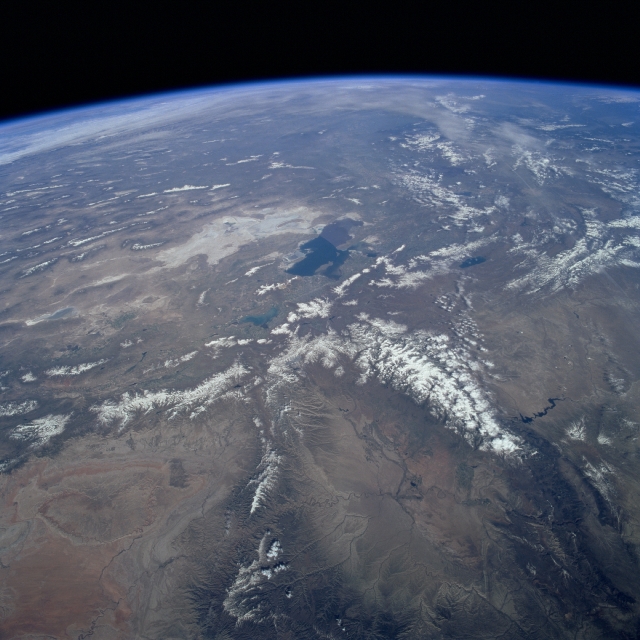 |
| STS090-752-094 Wasatch Mountains and Uinta Mountains, Utah April 1998 A northwest-looking image shows the rugged terrain of northern Utah extending westward and northward into the Basin and Range Province of northern Nevada and southern Oregon. The Great Salt Lake is visible just slightly above the center of the image. To the lake's west is the Great Salt Lake Desert, the floor of former Lake Bonneville. Just south of the Great Salt Lake and at the center of the image is Utah Lake. East of Utah Lake and extending north-south are the snow-covered peaks of the Wasatch Range, considered part of the Rocky Mountains. Extending in an east-west line are the faulted, snow-covered Uinta Mountains, which are also part of the Rocky Mountains. North of the Uinta Mountains near the right center of the image are the Great Divide Basin and the Flaming Gorge Reservoir of southwestern Wyoming. To the south of the Uinta Mountains and north of the Book Cliffs is the Uinta Basin, a major oil and natural gas region. Toward the bottom left of the image is the San Rafael Desert. |
| Images: | All Available Images Low-Resolution 302k |
|
| Mission: | STS090 |
|
| Roll - Frame: | 752 - 94 |
|
| Geographical Name: | USA-UTAH |
|
| Features: | PAN-GREAT SALT L. & DES. |
|
| Center Lat x Lon: | 41.0N x 112W |
|
| Film Exposure: | N | N=Normal exposure, U=Under exposed, O=Over exposed, F=out of Focus |
| Percentage of Cloud Cover-CLDP: | 10 |
|
| Camera:: | HB |
|
| Camera Tilt: | HO | LO=Low Oblique, HO=High Oblique, NV=Near Vertical |
| Camera Focal Length: | 40 |
|
| Nadir to Photo Center Direction: | NW | The direction from the nadir to the center point, N=North, S=South, E=East, W=West |
| Stereo?: | N | Y=Yes there is an adjacent picture of the same area, N=No there isn't |
| Orbit Number: | 240 |
|
| Date: | 19980502 | YYYYMMDD |
| Time: | 155514 | GMT HHMMSS |
| Nadir Lat: | 39.2N |
Latitude of suborbital point of spacecraft |
| Nadir Lon: | 108.5W |
Longitude of suborbital point of spacecraft |
| Sun Azimuth: | 105 | Clockwise angle in degrees from north to the sun measured at the nadir point |
| Space Craft Altitude: | 132 | nautical miles |
| Sun Elevation: | 41 | Angle in degrees between the horizon and the sun, measured at the nadir point |
| Land Views: | MOUNTAIN, PLATEAU, BASIN |
|
| Water Views: | LAKE |
|
| Atmosphere Views: | |
|
| Man Made Views: | |
|
| City Views: | |
|
Photo is not associated with any sequences | ||
| NASA Home Page |
JSC Home Page |
JSC Digital Image Collection |
Earth Science & Remote Sensing |
|
This service is provided by the International Space Station program and the JSC Earth Science & Remote Sensing Unit, ARES Division, Exploration Integration Science Directorate.

|