
Geographic Region: USA-VIRGINIA
Feature: RICHMOND, JAMES RIVER
|
Geographic Region: USA-VIRGINIA Feature: RICHMOND, JAMES RIVER |
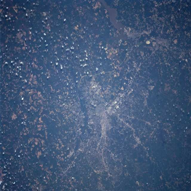 |
| STS090-752-062 Richmond/Petersburg, Virginia April 1998 The city of Richmond is located on the border of the physiographic regions of the Piedmont and the coastal plain. It is situated at the head of navigation on the James River. The city of Petersburg is located on the upper left of the image. The estuary of the James River is visible just below and left of the city. Petersburg is situated on the Appomattox River. Numerous Interstate Highways and other major highway transportation routes are discernible passing around and through both cities. Interstate Highway 295 is visible traversing north and south around the eastern sides of both cities. Swift Creek Reservoir is visible to the west of Richmond and Petersburg. |
| Images: | All Available Images Low-Resolution 363k |
|
| Mission: | STS090 |
|
| Roll - Frame: | 752 - 62 |
|
| Geographical Name: | USA-VIRGINIA |
|
| Features: | RICHMOND, JAMES RIVER |
|
| Center Lat x Lon: | 37.5N x 77.5W |
|
| Film Exposure: | N | N=Normal exposure, U=Under exposed, O=Over exposed, F=out of Focus |
| Percentage of Cloud Cover-CLDP: | 5 |
|
| Camera:: | HB |
|
| Camera Tilt: | 35 | LO=Low Oblique, HO=High Oblique, NV=Near Vertical |
| Camera Focal Length: | 250 |
|
| Nadir to Photo Center Direction: | SW | The direction from the nadir to the center point, N=North, S=South, E=East, W=West |
| Stereo?: | Y | Y=Yes there is an adjacent picture of the same area, N=No there isn't |
| Orbit Number: | 239 |
|
| Date: | 19980502 | YYYYMMDD |
| Time: | 142730 | GMT HHMMSS |
| Nadir Lat: | 38.6N |
Latitude of suborbital point of spacecraft |
| Nadir Lon: | 76.4W |
Longitude of suborbital point of spacecraft |
| Sun Azimuth: | 113 | Clockwise angle in degrees from north to the sun measured at the nadir point |
| Space Craft Altitude: | 132 | nautical miles |
| Sun Elevation: | 49 | Angle in degrees between the horizon and the sun, measured at the nadir point |
| Land Views: | PLAIN, FOREST |
|
| Water Views: | RIVER |
|
| Atmosphere Views: | |
|
| Man Made Views: | URBAN AREA, HIGHWAY |
|
| City Views: | RICHMOND |
|
Photo is not associated with any sequences | ||
| NASA Home Page |
JSC Home Page |
JSC Digital Image Collection |
Earth Science & Remote Sensing |
|
This service is provided by the International Space Station program and the JSC Earth Science & Remote Sensing Unit, ARES Division, Exploration Integration Science Directorate.

|