
Geographic Region: USA-COLORADO
Feature: SAND DUNES, SAN LUIS V.
|
Geographic Region: USA-COLORADO Feature: SAND DUNES, SAN LUIS V. |
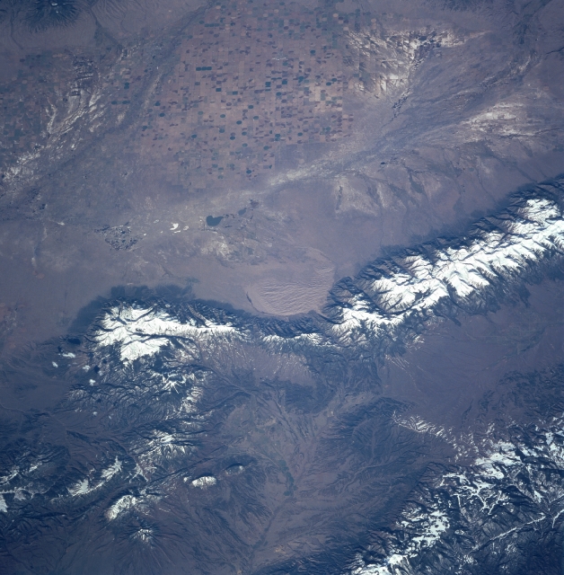 |
| STS090-752-036 San Luis Valley, Colorado, USA April 1998 The San Luis Valley in south central Colorado has an arid climate and is intensively cultivated for commercial agriculture. Even in this small-scale image, the widespread use of center pivot irrigation techniques is apparent. Notice several dendritic drainage patterns within the valley. These drainage patterns include the San Luis and Saguache Rivers in the northern section of the valley and the Rio Grand near the southwestern side. These patterns are enhanced by the highly mineralized surfaces (whitish looking saline soils) where agriculture is no longer possible due to the salinity of the soils. Great Sand Dunes National Monument is visible in the center of the picture. The snow-covered Sangre de Cristo Mountains border the east side of the San Luis Valley. |
| Images: | All Available Images Low-Resolution 344k |
|
| Mission: | STS090 |
|
| Roll - Frame: | 752 - 36 |
|
| Geographical Name: | USA-COLORADO |
|
| Features: | SAND DUNES, SAN LUIS V. |
|
| Center Lat x Lon: | 38.0N x 105.5W |
|
| Film Exposure: | N | N=Normal exposure, U=Under exposed, O=Over exposed, F=out of Focus |
| Percentage of Cloud Cover-CLDP: | 0 |
|
| Camera:: | HB |
|
| Camera Tilt: | 51 | LO=Low Oblique, HO=High Oblique, NV=Near Vertical |
| Camera Focal Length: | 250 |
|
| Nadir to Photo Center Direction: | W | The direction from the nadir to the center point, N=North, S=South, E=East, W=West |
| Stereo?: | Y | Y=Yes there is an adjacent picture of the same area, N=No there isn't |
| Orbit Number: | 239 |
|
| Date: | 19980502 | YYYYMMDD |
| Time: | 142207 | GMT HHMMSS |
| Nadir Lat: | 38.0N |
Latitude of suborbital point of spacecraft |
| Nadir Lon: | 102.7W |
Longitude of suborbital point of spacecraft |
| Sun Azimuth: | 92 | Clockwise angle in degrees from north to the sun measured at the nadir point |
| Space Craft Altitude: | 134 | nautical miles |
| Sun Elevation: | 28 | Angle in degrees between the horizon and the sun, measured at the nadir point |
| Land Views: | MOUNTAIN, VALLEY, DUNE, FOREST |
|
| Water Views: | RIVER |
|
| Atmosphere Views: | |
|
| Man Made Views: | AGRICULTURE, PIVOT IRRIGATION |
|
| City Views: | |
|
Photo is not associated with any sequences | ||
| NASA Home Page |
JSC Home Page |
JSC Digital Image Collection |
Earth Science & Remote Sensing |
|
This service is provided by the International Space Station program and the JSC Earth Science & Remote Sensing Unit, ARES Division, Exploration Integration Science Directorate.

|