
Geographic Region: USA-FLORIDA
Feature: KEY LARGO, EVERGLADES
|
Geographic Region: USA-FLORIDA Feature: KEY LARGO, EVERGLADES |
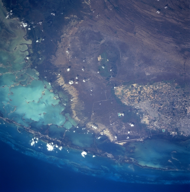 |
| STS090-751-54 South Florida, Florida, USA April 1998 Most of the southern tip of the mainland of Florida is visible in this easterly view that includes a variety of recognizable features. The highly reflective, light blue-green area along the southern edge of the picture is part of Florida Bay, a very shallow body of water where water depths rarely exceed 10 feet (3 meters). The darker landscape in the southwest corner of the picture is part of an extensive mangrove forest that borders the southern coastline of Florida. The alternating bands of light and dark (northwest corner) are sawgrass wetlands of Everglades National Park. In this section of the Everglades, water flow changes from the more characteristic north-south flow to a more southwesterly flow as it nears the coast. The city of Homestead (light-colored area north-center) is surrounded by extensive agriculture. A variety of vegetables are produced in this region of south Florida. Runways (light-colored lines) of Homestead Air Force Base are visible along the east edge of Homestead. The two even longer, parallel lines southeast of Homestead and adjacent to the southwest side of Biscayne Bay are cooling canals for the Turkey Point Power Generating Plant. The northern extent of the Florida Keys, a 225-mile (362-kilometer) chain of small islands that extends southwest from the Florida mainland, is also visible. Different shades of blue water here are roughly correlated with water depths--lighter shades of blue generally indicate water depths in the tens of feet, while darker blues can indicate depths in the hundreds of feet. |
| Images: | All Available Images Low-Resolution 309k |
|
| Mission: | STS090 |
|
| Roll - Frame: | 751 - 54 |
|
| Geographical Name: | USA-FLORIDA |
|
| Features: | KEY LARGO, EVERGLADES |
|
| Center Lat x Lon: | 25.5N x 80.5W |
|
| Film Exposure: | N | N=Normal exposure, U=Under exposed, O=Over exposed, F=out of Focus |
| Percentage of Cloud Cover-CLDP: | 0 |
|
| Camera:: | HB |
|
| Camera Tilt: | 38 | LO=Low Oblique, HO=High Oblique, NV=Near Vertical |
| Camera Focal Length: | 250 |
|
| Nadir to Photo Center Direction: | E | The direction from the nadir to the center point, N=North, S=South, E=East, W=West |
| Stereo?: | Y | Y=Yes there is an adjacent picture of the same area, N=No there isn't |
| Orbit Number: | 241 |
|
| Date: | 19980502 | YYYYMMDD |
| Time: | 173614 | GMT HHMMSS |
| Nadir Lat: | 25.8N |
Latitude of suborbital point of spacecraft |
| Nadir Lon: | 82.2W |
Longitude of suborbital point of spacecraft |
| Sun Azimuth: | 194 | Clockwise angle in degrees from north to the sun measured at the nadir point |
| Space Craft Altitude: | 131 | nautical miles |
| Sun Elevation: | 80 | Angle in degrees between the horizon and the sun, measured at the nadir point |
| Land Views: | PLAIN, ISLAND, FOREST |
|
| Water Views: | BAY, SWAMP, REEF |
|
| Atmosphere Views: | |
|
| Man Made Views: | AGRICULTURE, AIRPORT |
|
| City Views: | |
|
Photo is not associated with any sequences | ||
| NASA Home Page |
JSC Home Page |
JSC Digital Image Collection |
Earth Science & Remote Sensing |
|
This service is provided by the International Space Station program and the JSC Earth Science & Remote Sensing Unit, ARES Division, Exploration Integration Science Directorate.

|