
Geographic Region: USA-FLORIDA
Feature: MIAMI, EVERGLADES
|
Geographic Region: USA-FLORIDA Feature: MIAMI, EVERGLADES |
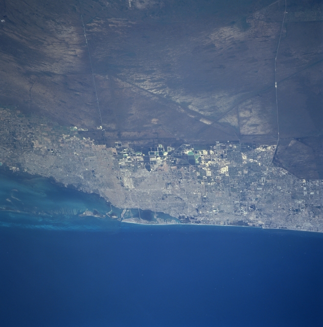 |
| STS090-751-047 Greater Miami Area, Florida, USA April 1998 The Everglades of southern Florida is the remainder of a wetland system that once covered more than four million acres (1600000 hectares). It is a landscape of flooded sawgrass prairies with numerous hardwood hammocks (islands of hardwood trees) scattered throughout the region on slightly elevated islands. As the water flows from north to south the Everglades functions as a natural water reclamation and recharge system. The light-colored north-south corridor along the Atlantic Ocean is the greater Miami urban area (from just north of Fort Lauderdale southward almost to Homestead). The two east-west, light-colored linear features that cut through the Everglades are Interstate Highway 75 (also known as Alligator Alley or Everglades Parkway ) and U. S. Highway 41. |
| Images: | All Available Images Low-Resolution 274k |
|
| Mission: | STS090 |
|
| Roll - Frame: | 751 - 47 |
|
| Geographical Name: | USA-FLORIDA |
|
| Features: | MIAMI, EVERGLADES |
|
| Center Lat x Lon: | 26.0N x 80W |
|
| Film Exposure: | N | N=Normal exposure, U=Under exposed, O=Over exposed, F=out of Focus |
| Percentage of Cloud Cover-CLDP: | 0 |
|
| Camera:: | HB |
|
| Camera Tilt: | 54 | LO=Low Oblique, HO=High Oblique, NV=Near Vertical |
| Camera Focal Length: | 250 |
|
| Nadir to Photo Center Direction: | E | The direction from the nadir to the center point, N=North, S=South, E=East, W=West |
| Stereo?: | Y | Y=Yes there is an adjacent picture of the same area, N=No there isn't |
| Orbit Number: | 241 |
|
| Date: | 19980502 | YYYYMMDD |
| Time: | 173601 | GMT HHMMSS |
| Nadir Lat: | 26.2N |
Latitude of suborbital point of spacecraft |
| Nadir Lon: | 83W |
Longitude of suborbital point of spacecraft |
| Sun Azimuth: | 189 | Clockwise angle in degrees from north to the sun measured at the nadir point |
| Space Craft Altitude: | 131 | nautical miles |
| Sun Elevation: | 79 | Angle in degrees between the horizon and the sun, measured at the nadir point |
| Land Views: | PLAIN, COAST |
|
| Water Views: | SWAMP, BAY |
|
| Atmosphere Views: | |
|
| Man Made Views: | HIGHWAY, URBAN AREA |
|
| City Views: | |
|
Photo is not associated with any sequences | ||
| NASA Home Page |
JSC Home Page |
JSC Digital Image Collection |
Earth Science & Remote Sensing |
|
This service is provided by the International Space Station program and the JSC Earth Science & Remote Sensing Unit, ARES Division, Exploration Integration Science Directorate.

|