
Geographic Region: USA-FLORIDA
Feature: BOCA RATON, EVERGLADES
|
Geographic Region: USA-FLORIDA Feature: BOCA RATON, EVERGLADES |
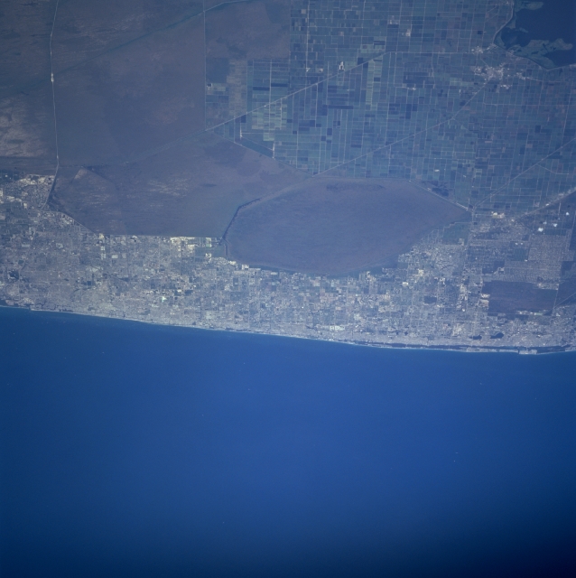 |
| STS090-751-045 Southeast Coast, Florida, USA April 1998 Four distinct features are evident in this shot of the southeast coast of Florida: cultivated field patterns (northwest); poorly drained swamplands (center, southwest); urban sprawl (north-south corridor along coast); and the Atlantic Ocean. The large fields of sugarcane (southeast of Lake Okeechobee, lower left corner) are gridded by canals and roads (linear, northwest-southeast diagonal lines). The muddy looking, uniform area south, southeast of the agricultural land are wetlands upstream from the Everglades. The most northeasterly wetland polygon is Arthur R. Mitchell National Wildlife Refuge. The very light areas along the east coast of Florida are the urban areas that extend from West Palm Beach (north) to Fort Lauderdale (south). The white line running east-west near the southern edge of the image is Interstate Highway 75, otherwise known as Alligator Alley (Everglades Parkway). |
| Images: | All Available Images Low-Resolution 246k |
|
| Mission: | STS090 |
|
| Roll - Frame: | 751 - 45 |
|
| Geographical Name: | USA-FLORIDA |
|
| Features: | BOCA RATON, EVERGLADES |
|
| Center Lat x Lon: | 26.5N x 80W |
|
| Film Exposure: | N | N=Normal exposure, U=Under exposed, O=Over exposed, F=out of Focus |
| Percentage of Cloud Cover-CLDP: | 0 |
|
| Camera:: | HB |
|
| Camera Tilt: | LO | LO=Low Oblique, HO=High Oblique, NV=Near Vertical |
| Camera Focal Length: | 250 |
|
| Nadir to Photo Center Direction: | E | The direction from the nadir to the center point, N=North, S=South, E=East, W=West |
| Stereo?: | Y | Y=Yes there is an adjacent picture of the same area, N=No there isn't |
| Orbit Number: | 241 |
|
| Date: | 19980502 | YYYYMMDD |
| Time: | 173557 | GMT HHMMSS |
| Nadir Lat: | 26.4N |
Latitude of suborbital point of spacecraft |
| Nadir Lon: | 83.2W |
Longitude of suborbital point of spacecraft |
| Sun Azimuth: | 188 | Clockwise angle in degrees from north to the sun measured at the nadir point |
| Space Craft Altitude: | 131 | nautical miles |
| Sun Elevation: | 79 | Angle in degrees between the horizon and the sun, measured at the nadir point |
| Land Views: | PLAIN, COAST |
|
| Water Views: | SWAMP, CANAL |
|
| Atmosphere Views: | |
|
| Man Made Views: | AGRICULTURE, URBAN AREA, HIGHWAY |
|
| City Views: | |
|
Photo is not associated with any sequences | ||
| NASA Home Page |
JSC Home Page |
JSC Digital Image Collection |
Earth Science & Remote Sensing |
|
This service is provided by the International Space Station program and the JSC Earth Science & Remote Sensing Unit, ARES Division, Exploration Integration Science Directorate.

|