
Geographic Region: USA-TEXAS
Feature: BEAUMONT, SMOKE
|
Geographic Region: USA-TEXAS Feature: BEAUMONT, SMOKE |
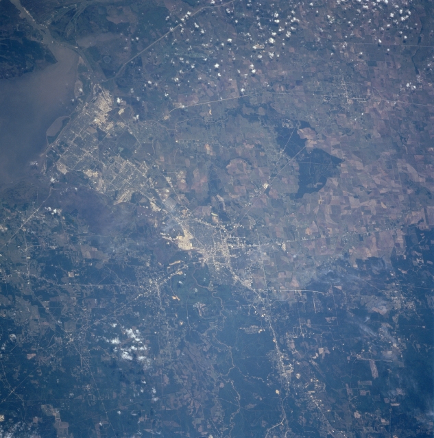 |
| STS090-751-027 Beaumont and Port Arthur, Texas, USA April 1998 An extensive highway network (light colored lines) provides ground linkage between the cities of Beaumont (near the center of the image) and Port Arthur (top left), as well as other urban areas in southeast Texas and southwest Louisiana. Gridded street patterns and a gray color indicate these two industrial cities. A segment of Interstate Highway 10 can be traced diagonally (top right to lower left) crossing the flat, coastal plains and passing through downtown Beaumont. Sabine Lake and Sabine Pass (dark looking water outlet to the Gulf of Mexico) are visible in the southeast corner (upper left) of the picture. The Nueces River and its heavily wooded, broad floodplain is more difficult to identify along the eastern side of the Beaumont and Port Arthur urban areas. The darker looking area north of Beaumont is the southern edge of the well-known Piney Woods of east Texas. This largely undeveloped region contrasts with the angular patterns of the cultivated fields, which are mainly large rice fields, west and southwest of Beaumont. Sugar cane is grown in selected areas closer to the coast. Notice the large stand of trees (darker landscape, lower left corner) that is located midway between the cities of Beaumont and Winnie. |
| Images: | All Available Images Low-Resolution 339k |
|
| Mission: | STS090 |
|
| Roll - Frame: | 751 - 27 |
|
| Geographical Name: | USA-TEXAS |
|
| Features: | BEAUMONT, SMOKE |
|
| Center Lat x Lon: | 30.0N x 94W |
|
| Film Exposure: | N | N=Normal exposure, U=Under exposed, O=Over exposed, F=out of Focus |
| Percentage of Cloud Cover-CLDP: | 5 |
|
| Camera:: | HB |
|
| Camera Tilt: | 34 | LO=Low Oblique, HO=High Oblique, NV=Near Vertical |
| Camera Focal Length: | 250 |
|
| Nadir to Photo Center Direction: | SW | The direction from the nadir to the center point, N=North, S=South, E=East, W=West |
| Stereo?: | N | Y=Yes there is an adjacent picture of the same area, N=No there isn't |
| Orbit Number: | 241 |
|
| Date: | 19980502 | YYYYMMDD |
| Time: | 173322 | GMT HHMMSS |
| Nadir Lat: | 31.2N |
Latitude of suborbital point of spacecraft |
| Nadir Lon: | 93.1W |
Longitude of suborbital point of spacecraft |
| Sun Azimuth: | 150 | Clockwise angle in degrees from north to the sun measured at the nadir point |
| Space Craft Altitude: | 131 | nautical miles |
| Sun Elevation: | 72 | Angle in degrees between the horizon and the sun, measured at the nadir point |
| Land Views: | PLAIN, FOREST |
|
| Water Views: | RIVER, LAKE |
|
| Atmosphere Views: | |
|
| Man Made Views: | HIGHWAY, URBAN AREA, AGRICULTURE |
|
| City Views: | BEAUMONT, PORT ARTHUR |
|
Photo is not associated with any sequences | ||
| NASA Home Page |
JSC Home Page |
JSC Digital Image Collection |
Earth Science & Remote Sensing |
|
This service is provided by the International Space Station program and the JSC Earth Science & Remote Sensing Unit, ARES Division, Exploration Integration Science Directorate.

|