
Geographic Region: USA-NEW MEXICO
Feature: GALLINA PEAK, ROCKY MTS.
|
Geographic Region: USA-NEW MEXICO Feature: GALLINA PEAK, ROCKY MTS. |
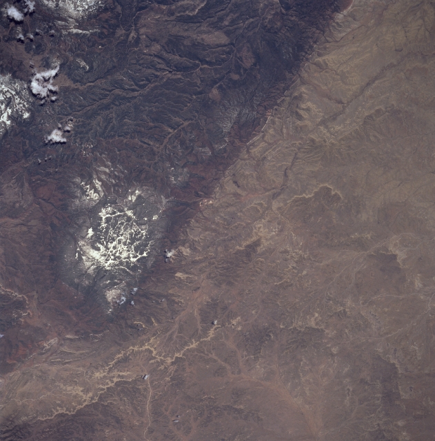 |
| STS090-751-018 Nacimiento Fault, New Mexico, USA April 1998 Most of the time in nature straight lines do not occur but in this scene the north-south aligned Nacimiento Fault presents a dramatic boundary, seen here extending from near the top left corner towards the center of the view. The boundary clearly demarcates the elevated Precambrian rocks of the San Pedro Parks, which appear wooded and therefore darker (lower left) from the sedimentary rocks of the lower San Juan Basin, where drier grasslands appear light brown (mainly in the upper half of the view). Several dry stream channels which only flow intermittently can be discerned in this part of the San Juan Basin, which lies generally less than 7000 feet (2134 meters) above sea level. Streams on the eastern side of the fault follow a series of deeply incised river valleys as they flow south around the west side of the Valles Caldera. Some of the individual cinder cones within the Valles Caldera are visible in the east corner (bottom left) of the image. The snow-covered plateau (just below the center of the picture) has elevations of more than 10,000 feet (3234 meters) above sea level so that cold temperatures preserve the snow cover. |
| Images: | All Available Images Low-Resolution 313k |
|
| Mission: | STS090 |
|
| Roll - Frame: | 751 - 18 |
|
| Geographical Name: | USA-NEW MEXICO |
|
| Features: | GALLINA PEAK, ROCKY MTS. |
|
| Center Lat x Lon: | 36.0N x 107W |
|
| Film Exposure: | N | N=Normal exposure, U=Under exposed, O=Over exposed, F=out of Focus |
| Percentage of Cloud Cover-CLDP: | 5 |
|
| Camera:: | HB |
|
| Camera Tilt: | 34 | LO=Low Oblique, HO=High Oblique, NV=Near Vertical |
| Camera Focal Length: | 250 |
|
| Nadir to Photo Center Direction: | W | The direction from the nadir to the center point, N=North, S=South, E=East, W=West |
| Stereo?: | N | Y=Yes there is an adjacent picture of the same area, N=No there isn't |
| Orbit Number: | 241 |
|
| Date: | 19980502 | YYYYMMDD |
| Time: | 173025 | GMT HHMMSS |
| Nadir Lat: | 35.5N |
Latitude of suborbital point of spacecraft |
| Nadir Lon: | 105.6W |
Longitude of suborbital point of spacecraft |
| Sun Azimuth: | 129 | Clockwise angle in degrees from north to the sun measured at the nadir point |
| Space Craft Altitude: | 131 | nautical miles |
| Sun Elevation: | 62 | Angle in degrees between the horizon and the sun, measured at the nadir point |
| Land Views: | MOUNTAIN, FAULT |
|
| Water Views: | |
|
| Atmosphere Views: | |
|
| Man Made Views: | |
|
| City Views: | |
|
Photo is not associated with any sequences | ||
| NASA Home Page |
JSC Home Page |
JSC Digital Image Collection |
Earth Science & Remote Sensing |
|
This service is provided by the International Space Station program and the JSC Earth Science & Remote Sensing Unit, ARES Division, Exploration Integration Science Directorate.

|