
Geographic Region: USA-UTAH
Feature: SAN JUAN R., CO. PLATEAU
|
Geographic Region: USA-UTAH Feature: SAN JUAN R., CO. PLATEAU |
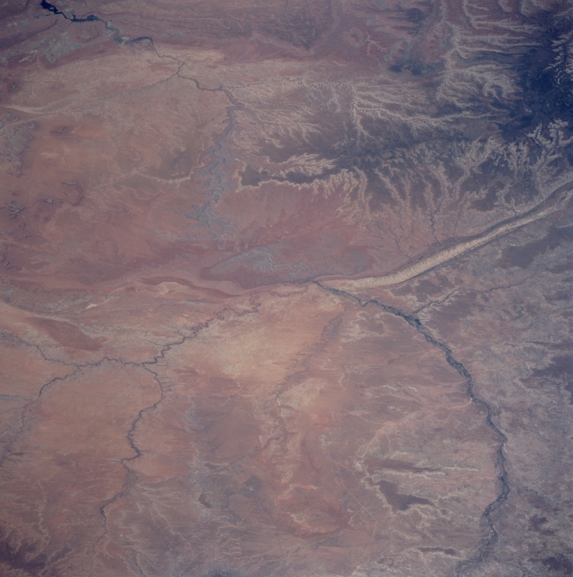 |
| STS090-751-014 Colorado Plateau, San Juan River, Utah April 1998 The San Juan River can be seen entering the scene at the bottom right and traversing the center of the image, exiting upper left, in this west-northwest-looking view. Over 400 miles (645 km) long, the San Juan River rises in the San Juan Mountains of southwestern Colorado and flows generally westward across the Colorado Plateau emptying into Lake Powell on the Colorado River. The river is used extensively for irrigation. Vegetables, fruits, and grains are grown in the river valley. The Colorado Plateau covers an area of 150000 sq. miles (388500 sq. km) in the states of Arizona, Colorado, New Mexico, and Utah. The region consists of broad plateaus, ancient volcanic mountains, and deeply dissected great canyons carved into nearly horizontal and often brightly colored sedimentary and volcanic rocks. The Colorado Plateau is basically semi-arid and is sparsely vegetated, except for the higher mountain ranges and irrigated river valleys. Near the upper left portion of the image, Rainbow Plateau is visible. Just left center of the image is Monument Valley. The Southern portions of the Abajo Mountains are discernible in the upper right portion of the image. |
| Images: | All Available Images Low-Resolution 289k |
|
| Mission: | STS090 |
|
| Roll - Frame: | 751 - 14 |
|
| Geographical Name: | USA-UTAH |
|
| Features: | SAN JUAN R., CO. PLATEAU |
|
| Center Lat x Lon: | 37.0N x 110W |
|
| Film Exposure: | N | N=Normal exposure, U=Under exposed, O=Over exposed, F=out of Focus |
| Percentage of Cloud Cover-CLDP: | 0 |
|
| Camera:: | HB |
|
| Camera Tilt: | 55 | LO=Low Oblique, HO=High Oblique, NV=Near Vertical |
| Camera Focal Length: | 250 |
|
| Nadir to Photo Center Direction: | W | The direction from the nadir to the center point, N=North, S=South, E=East, W=West |
| Stereo?: | Y | Y=Yes there is an adjacent picture of the same area, N=No there isn't |
| Orbit Number: | 241 |
|
| Date: | 19980502 | YYYYMMDD |
| Time: | 173005 | GMT HHMMSS |
| Nadir Lat: | 35.9N |
Latitude of suborbital point of spacecraft |
| Nadir Lon: | 107.1W |
Longitude of suborbital point of spacecraft |
| Sun Azimuth: | 127 | Clockwise angle in degrees from north to the sun measured at the nadir point |
| Space Craft Altitude: | 131 | nautical miles |
| Sun Elevation: | 61 | Angle in degrees between the horizon and the sun, measured at the nadir point |
| Land Views: | PLATEAU, ESCARPMENT |
|
| Water Views: | RIVER |
|
| Atmosphere Views: | |
|
| Man Made Views: | |
|
| City Views: | |
|
Photo is not associated with any sequences | ||
| NASA Home Page |
JSC Home Page |
JSC Digital Image Collection |
Earth Science & Remote Sensing |
|
This service is provided by the International Space Station program and the JSC Earth Science & Remote Sensing Unit, ARES Division, Exploration Integration Science Directorate.

|