
Geographic Region: USA-NORTH CAROLINA
Feature: CAPE LOOKOUT,NEUSE RIVER
|
Geographic Region: USA-NORTH CAROLINA Feature: CAPE LOOKOUT,NEUSE RIVER |
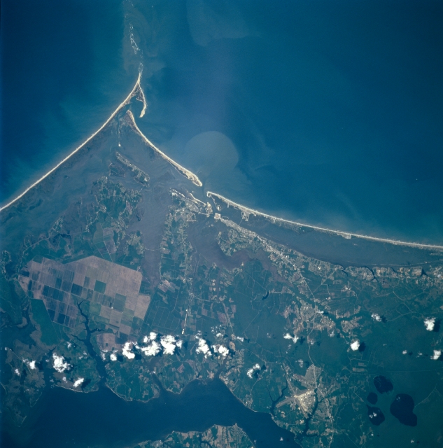 |
| STS090-750-095 Morehead City, Cape lookout, North Carolina April, 1998 Cape Lookout and the southern portions of the Cape Lookout National Seashore, and the Crystal Coast to the west of Cape Lookout, can be seen in this west-looking view. Two of the three barrier islands of the Cape Lookout National Seashore, South Core Banks on which Cape Lookout is visible, and Shackleford Banks, the barrier island just to the west or right of Cape Lookout, are visible. The total Cape Lookout National Seashore is 55 miles (89 km) long and consist of three low, narrow, sand islands. The islands are wide beaches with low sand dunes covered by scattered grasses. Somewhat inland off the Atlantic Ocean beaches, the island consists of flat grasslands bordered by dense vegetation and large expanse of salt marshes along side the inland sounds. Winds, waves, and currents continually are at work reshaping the barrier islands. Morehead City is discernible near the center of the image. Morehead City is one of two deep-water ports in North Carolina. Tourism, fishing, and boat building are the major economic activities of the city. Along the right center to the bottom right of the image, the Neuse River Estuary can be seen. The Crystal Coast area of North Carolina is visible beginning at Morehead City and extending westward to the upper right portion of the image. The largest of the four lakes discernible in the upper right portion of the image is Great Lake. These lakes are situated in the Croatan National Forest. |
| Images: | All Available Images Low-Resolution 290k |
|
| Mission: | STS090 |
|
| Roll - Frame: | 750 - 95 |
|
| Geographical Name: | USA-NORTH CAROLINA |
|
| Features: | CAPE LOOKOUT,NEUSE RIVER |
|
| Center Lat x Lon: | 34.5N x 76.5W |
|
| Film Exposure: | N | N=Normal exposure, U=Under exposed, O=Over exposed, F=out of Focus |
| Percentage of Cloud Cover-CLDP: | 5 |
|
| Camera:: | HB |
|
| Camera Tilt: | 26 | LO=Low Oblique, HO=High Oblique, NV=Near Vertical |
| Camera Focal Length: | 250 |
|
| Nadir to Photo Center Direction: | NE | The direction from the nadir to the center point, N=North, S=South, E=East, W=West |
| Stereo?: | Y | Y=Yes there is an adjacent picture of the same area, N=No there isn't |
| Orbit Number: | 240 |
|
| Date: | 19980502 | YYYYMMDD |
| Time: | 160215 | GMT HHMMSS |
| Nadir Lat: | 33.9N |
Latitude of suborbital point of spacecraft |
| Nadir Lon: | 77.4W |
Longitude of suborbital point of spacecraft |
| Sun Azimuth: | 138 | Clockwise angle in degrees from north to the sun measured at the nadir point |
| Space Craft Altitude: | 131 | nautical miles |
| Sun Elevation: | 67 | Angle in degrees between the horizon and the sun, measured at the nadir point |
| Land Views: | COAST, DUNE, FOREST, CAPE |
|
| Water Views: | ESTUARY, LAKE, BAY |
|
| Atmosphere Views: | |
|
| Man Made Views: | |
|
| City Views: | |
|
Photo is not associated with any sequences | ||
| NASA Home Page |
JSC Home Page |
JSC Digital Image Collection |
Earth Science & Remote Sensing |
|
This service is provided by the International Space Station program and the JSC Earth Science & Remote Sensing Unit, ARES Division, Exploration Integration Science Directorate.

|