
Geographic Region: USA-COLORADO
Feature: DENVER, AIRPORT
|
Geographic Region: USA-COLORADO Feature: DENVER, AIRPORT |
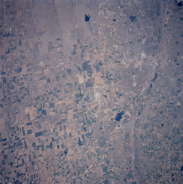 |
| STS090-750-062 Denver International Airport, Colorado, USA April 1998 The multiple runways of the Denver International Airport can be seen in the center of the image. The light colored, linear features that are located south and west of the airport are Interstate Highway 70 (east-west)and Interstate Highway 76 (northeast- southwest), respectively. Most of the rural land in the scene of the western High Plains shows a variety of cultivated field patterns of varying sizes, shapes (rectangular), and colors, where irrigation and dry land farming is practiced. The region receives an average 15 inches (38 cm) of precipitation per year, producing a semi arid climate. A few circular fields indicate that the center pivot irrigation technique is being used on a limited basis in the region. Barr Lake, a state park (dark feature northwest of the airport), is located on the Beebe Seep Canal. Immediately west of this feature, the gently curving floodplain of the South Platte River is barely visible as it heads northward. Most of the southwestern quadrant of the picture consists of urban development, as the cities of Denver and Aurora expand eastward. Cherry Creek Lake (dark feature with a smooth-looking shoreline southwest of the airport) is gradually being encircled by urban growth. This image is oriented with north at the bottom. |
| Images: | All Available Images Low-Resolution 363k |
|
| Mission: | STS090 |
|
| Roll - Frame: | 750 - 62 |
|
| Geographical Name: | USA-COLORADO |
|
| Features: | DENVER, AIRPORT |
|
| Center Lat x Lon: | 40.0N x 104.5W |
|
| Film Exposure: | N | N=Normal exposure, U=Under exposed, O=Over exposed, F=out of Focus |
| Percentage of Cloud Cover-CLDP: | 0 |
|
| Camera:: | HB |
|
| Camera Tilt: | NV | LO=Low Oblique, HO=High Oblique, NV=Near Vertical |
| Camera Focal Length: | 250 |
|
| Nadir to Photo Center Direction: | NW | The direction from the nadir to the center point, N=North, S=South, E=East, W=West |
| Stereo?: | Y | Y=Yes there is an adjacent picture of the same area, N=No there isn't |
| Orbit Number: | 240 |
|
| Date: | 19980502 | YYYYMMDD |
| Time: | 155638 | GMT HHMMSS |
| Nadir Lat: | 39.0N |
Latitude of suborbital point of spacecraft |
| Nadir Lon: | 103.5W |
Longitude of suborbital point of spacecraft |
| Sun Azimuth: | 109 | Clockwise angle in degrees from north to the sun measured at the nadir point |
| Space Craft Altitude: | 132 | nautical miles |
| Sun Elevation: | 45 | Angle in degrees between the horizon and the sun, measured at the nadir point |
| Land Views: | PLAIN |
|
| Water Views: | RIVER, LAKE |
|
| Atmosphere Views: | |
|
| Man Made Views: | AIRPORT, AGRICULTURE |
|
| City Views: | DENVER |
|
Photo is not associated with any sequences | ||
| NASA Home Page |
JSC Home Page |
JSC Digital Image Collection |
Earth Science & Remote Sensing |
|
This service is provided by the International Space Station program and the JSC Earth Science & Remote Sensing Unit, ARES Division, Exploration Integration Science Directorate.

|