
Geographic Region: USA-ARIZONA
Feature: HUMPHREYS PEAK, CRATER
|
Geographic Region: USA-ARIZONA Feature: HUMPHREYS PEAK, CRATER |
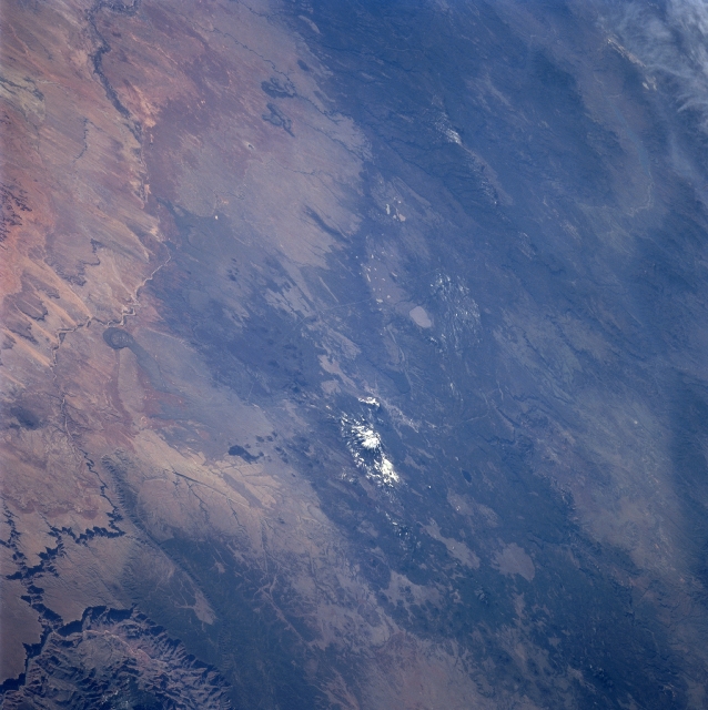 |
| STS090-750-049 San Francisco Mountains, Arizona, USA April 1998 The San Francisco Mountains (volcanic field), including snow capped Humphrey's Peak (12,633 feet--3851 meters) the highest point in Arizona, is visible near the center of the picture. The city of Flagstaff (not distinctive in this wide view) is located immediately south of Humphrey's Peak. The lighter colored, oval shaped feature southeast of Humphrey's Peak is Mormon Lake. Southeast of Mormon Lake, part of the Mogollon Plateau can be seen as it extends in a general east-west direction. Northeast of Humphrey's Peak a section of the Painted Desert of north central Arizona is visible. The intermittently flowing Little Colorado River and its deeply incised stream channel can be traced across this arid environment as it heads northwest, eventually entering the Colorado River at the eastern end of the Grand Canyon (northern or lower right corner of the image). |
| Images: | All Available Images Low-Resolution 312k |
|
| Mission: | STS090 |
|
| Roll - Frame: | 750 - 49 |
|
| Geographical Name: | USA-ARIZONA |
|
| Features: | HUMPHREYS PEAK, CRATER |
|
| Center Lat x Lon: | 35.5N x 111.5W |
|
| Film Exposure: | N | N=Normal exposure, U=Under exposed, O=Over exposed, F=out of Focus |
| Percentage of Cloud Cover-CLDP: | 5 |
|
| Camera:: | HB |
|
| Camera Tilt: | LO | LO=Low Oblique, HO=High Oblique, NV=Near Vertical |
| Camera Focal Length: | 250 |
|
| Nadir to Photo Center Direction: | S | The direction from the nadir to the center point, N=North, S=South, E=East, W=West |
| Stereo?: | Y | Y=Yes there is an adjacent picture of the same area, N=No there isn't |
| Orbit Number: | 240 |
|
| Date: | 19980502 | YYYYMMDD |
| Time: | 155444 | GMT HHMMSS |
| Nadir Lat: | 39.1N |
Latitude of suborbital point of spacecraft |
| Nadir Lon: | 112.8W |
Longitude of suborbital point of spacecraft |
| Sun Azimuth: | 101 | Clockwise angle in degrees from north to the sun measured at the nadir point |
| Space Craft Altitude: | 133 | nautical miles |
| Sun Elevation: | 38 | Angle in degrees between the horizon and the sun, measured at the nadir point |
| Land Views: | MOUNTAIN |
|
| Water Views: | RIVER |
|
| Atmosphere Views: | |
|
| Man Made Views: | |
|
| City Views: | |
|
Photo is not associated with any sequences | ||
| NASA Home Page |
JSC Home Page |
JSC Digital Image Collection |
Earth Science & Remote Sensing |
|
This service is provided by the International Space Station program and the JSC Earth Science & Remote Sensing Unit, ARES Division, Exploration Integration Science Directorate.

|