Geographic Region: PORTUGAL
Feature: LISBON, TAGUS RIVER
|
Geographic Region: PORTUGAL Feature: LISBON, TAGUS RIVER |
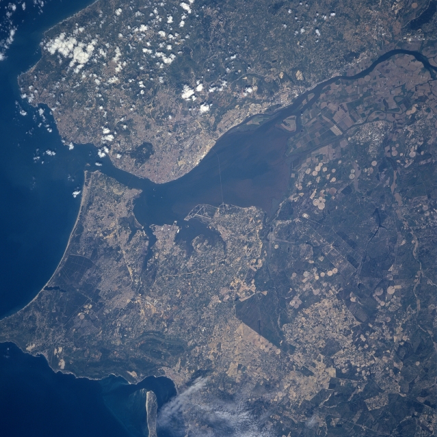 |
| STS090-748-093 Lisbon, Portugal April 1998 Lisbon, the nation's capital and largest city (estimated population of 650000 people), is located along the west side and near the mouth of the Tagus River estuary (large, dark feature in center of image). The Tagus River estuary is one of the best natural ports on the European continent and can accommodate large ocean going ships. The estuary also has the largest dry dock in the world. The intersecting runways for one of Lisbon's several airports are visible on a peninsula that extends westerly into the south side of the Tagus River estuary. Two bridges can be seen connecting the eastern shore with the built-up area of Lisbon. With the exception of the alluvial soil deposited by the Tagus River and the irrigated acreage along the delta and floodplain of the river, Portugal is not a country that has an abundance of arable land. The angular-looking field patterns found on the Tagus River delta (near upper right corner) and the circular patterns (center pivot irrigation southeast of the river) show the location and distribution of some of the productive farmland. The greater Lisbon area, including both the city and its suburbs, accounts for most of Portugal's commerce and much of its industry. |
| Images: | All Available Images Low-Resolution 368k |
|
| Mission: | STS090 |
|
| Roll - Frame: | 748 - 93 |
|
| Geographical Name: | PORTUGAL |
|
| Features: | LISBON, TAGUS RIVER |
|
| Center Lat x Lon: | 38.5N x 9W |
|
| Film Exposure: | N | N=Normal exposure, U=Under exposed, O=Over exposed, F=out of Focus |
| Percentage of Cloud Cover-CLDP: | 5 |
|
| Camera:: | HB |
|
| Camera Tilt: | 36 | LO=Low Oblique, HO=High Oblique, NV=Near Vertical |
| Camera Focal Length: | 250 |
|
| Nadir to Photo Center Direction: | W | The direction from the nadir to the center point, N=North, S=South, E=East, W=West |
| Stereo?: | Y | Y=Yes there is an adjacent picture of the same area, N=No there isn't |
| Orbit Number: | 236 |
|
| Date: | 19980502 | YYYYMMDD |
| Time: | 095850 | GMT HHMMSS |
| Nadir Lat: | 38.6N |
Latitude of suborbital point of spacecraft |
| Nadir Lon: | 7.4W |
Longitude of suborbital point of spacecraft |
| Sun Azimuth: | 115 | Clockwise angle in degrees from north to the sun measured at the nadir point |
| Space Craft Altitude: | 132 | nautical miles |
| Sun Elevation: | 50 | Angle in degrees between the horizon and the sun, measured at the nadir point |
| Land Views: | PLAIN |
|
| Water Views: | RIVER, ESTUARY, DELTA |
|
| Atmosphere Views: | |
|
| Man Made Views: | AIRPORT, AGRICULTURE |
|
| City Views: | |
|
Photo is not associated with any sequences | ||
| NASA Home Page |
JSC Home Page |
JSC Digital Image Collection |
Earth Science & Remote Sensing |
|
This service is provided by the International Space Station program and the JSC Earth Science & Remote Sensing Unit, ARES Division, Exploration Integration Science Directorate.

|