Geographic Region: JAPAN
Feature: NAGOYA, KUWANA, ISE BAY
|
Geographic Region: JAPAN Feature: NAGOYA, KUWANA, ISE BAY |
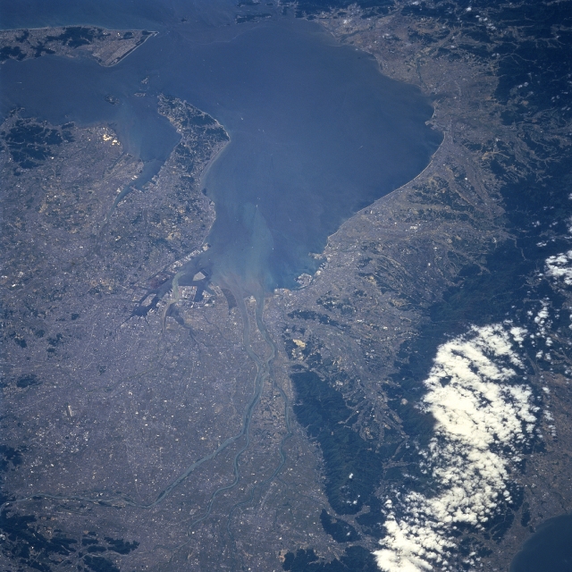 |
| STS090-743-28 Nagoya Area, Honshu, Japan April 1998 The urban center of Nagoya, a Japanese city of over 2 million people, is located along the northeast corner of Ise Bay. Located along the southeast Pacific coast of Honshu Island, Nagoya is acknowledged to be a major port, transportation hub, and highly industrialized city of Japan. The urban, built-up city of Nagoya merges with numerous smaller cities and even limited cultivated land, producing the extensive lighter-colored landscape that dominates this southerly view of Ise Bay. Like most of Japan (where mountains occupy about 80 percent of the total land area) wherever alluvial soils and flat plains are found urban development and agriculture compete for the use of the land. Several short-flowing rivers, including the Nagara River, can be seen entering the northern end of Ise Bay. A sediment plume is visible flowing southward from the delta created by these rivers into Ise Bay. The darker, partially cloud covered terrain west of the Nagoya metropolitan area are rugged, forested mountains (volcanic in origin). |
| Images: | All Available Images Low-Resolution 353k |
|
| Mission: | STS090 |
|
| Roll - Frame: | 743 - 28 |
|
| Geographical Name: | JAPAN |
|
| Features: | NAGOYA, KUWANA, ISE BAY |
|
| Center Lat x Lon: | 35.0N x 136.5E |
|
| Film Exposure: | N | N=Normal exposure, U=Under exposed, O=Over exposed, F=out of Focus |
| Percentage of Cloud Cover-CLDP: | 5 |
|
| Camera:: | HB |
|
| Camera Tilt: | 44 | LO=Low Oblique, HO=High Oblique, NV=Near Vertical |
| Camera Focal Length: | 250 |
|
| Nadir to Photo Center Direction: | S | The direction from the nadir to the center point, N=North, S=South, E=East, W=West |
| Stereo?: | Y | Y=Yes there is an adjacent picture of the same area, N=No there isn't |
| Orbit Number: | 134 |
|
| Date: | 19980426 | YYYYMMDD |
| Time: | 012709 | GMT HHMMSS |
| Nadir Lat: | 37.1N |
Latitude of suborbital point of spacecraft |
| Nadir Lon: | 136.1E |
Longitude of suborbital point of spacecraft |
| Sun Azimuth: | 135 | Clockwise angle in degrees from north to the sun measured at the nadir point |
| Space Craft Altitude: | 133 | nautical miles |
| Sun Elevation: | 60 | Angle in degrees between the horizon and the sun, measured at the nadir point |
| Land Views: | MOUNTAIN, PLAIN |
|
| Water Views: | BAY, RIVER |
|
| Atmosphere Views: | |
|
| Man Made Views: | URBAN AREA |
|
| City Views: | |
|
Photo is not associated with any sequences | ||
| NASA Home Page |
JSC Home Page |
JSC Digital Image Collection |
Earth Science & Remote Sensing |
|
This service is provided by the International Space Station program and the JSC Earth Science & Remote Sensing Unit, ARES Division, Exploration Integration Science Directorate.

|