
Geographic Region: USA-NEVADA
Feature: LAS VEGAS
|
Geographic Region: USA-NEVADA Feature: LAS VEGAS |
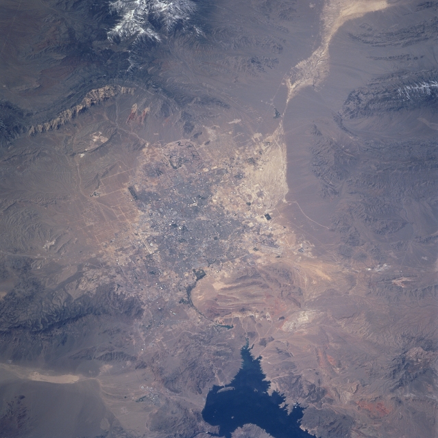 |
| STS090-740-063 Las Vegas Valley, Nevada, USA April 1998 This photograph shows one of the United States' fastest growing metropolitan areas --Las Vegas. The city lies in a valley surrounded by the Spring Mountains (to the west), the Sheep Range (to the north), Muddy Mountains (to the northeast), and the McCullough Range (to the south). The snow-capped Spring Mountains include Mt. Charleston (11,918 feet--3633 meters above sea level), a favorite tourist spot located forty miles (64 kilometers) northwest of Las Vegas. The lighter colored, connected diamond shapes northwest of the urban area are a series of dry washes and salt pans with virtually no vegetation. The dark feature along the eastern edge (bottom middle) of the image is the western end of Lake Mead. Detailed infrastructure of the city is not visible at this scale, except the white V-shaped runways of McCarran International Airport (on the south edge of the built-up area) and the overall gridded street pattern. |
| Images: | All Available Images Low-Resolution 317k |
|
| Mission: | STS090 |
|
| Roll - Frame: | 740 - 63 |
|
| Geographical Name: | USA-NEVADA |
|
| Features: | LAS VEGAS |
|
| Center Lat x Lon: | 36.0N x 115W |
|
| Film Exposure: | N | N=Normal exposure, U=Under exposed, O=Over exposed, F=out of Focus |
| Percentage of Cloud Cover-CLDP: | 0 |
|
| Camera:: | HB |
|
| Camera Tilt: | 42 | LO=Low Oblique, HO=High Oblique, NV=Near Vertical |
| Camera Focal Length: | 250 |
|
| Nadir to Photo Center Direction: | W | The direction from the nadir to the center point, N=North, S=South, E=East, W=West |
| Stereo?: | Y | Y=Yes there is an adjacent picture of the same area, N=No there isn't |
| Orbit Number: | 147 |
|
| Date: | 19980426 | YYYYMMDD |
| Time: | 210325 | GMT HHMMSS |
| Nadir Lat: | 35.4N |
Latitude of suborbital point of spacecraft |
| Nadir Lon: | 113.1W |
Longitude of suborbital point of spacecraft |
| Sun Azimuth: | 230 | Clockwise angle in degrees from north to the sun measured at the nadir point |
| Space Craft Altitude: | 133 | nautical miles |
| Sun Elevation: | 60 | Angle in degrees between the horizon and the sun, measured at the nadir point |
| Land Views: | DESERT, MOUNTAIN |
|
| Water Views: | LAKE, PLAYA |
|
| Atmosphere Views: | |
|
| Man Made Views: | URBAN AREA |
|
| City Views: | |
|
Photo is not associated with any sequences | ||
| NASA Home Page |
JSC Home Page |
JSC Digital Image Collection |
Earth Science & Remote Sensing |
|
This service is provided by the International Space Station program and the JSC Earth Science & Remote Sensing Unit, ARES Division, Exploration Integration Science Directorate.

|