Geographic Region: JAPAN
Feature: KYUSHU, AMAKUSA SEA
|
Geographic Region: JAPAN Feature: KYUSHU, AMAKUSA SEA |
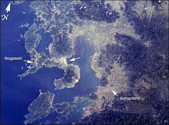 |
| STS090-739-79 Ariake Sea, Japan April 1998 The Isahaya Bay Reclamation project separated approximately 3,000 hectares of tidal flats from the Ariake Sea in 1997. This photograph was taken from the Space Shuttle on April 27, 1998, a year after the sea wall separating Isahaya Bay from the rest of the Ariake Sea was closed. The reflective white area (center arrow) shows the straight edge of the sea wall and the drying tidal flats. The project has been highly controversial because of concerns by environmental groups about the loss of wetland habitat. Hirofumi Yamashita was awarded the 1998 Goldman Environmental Prize for his scientific efforts documenting the ecological value of the bay and his grassroots activism trying to stop the closing of the sea wall. In 1992, he catalyzed other organizations to form the Japan Wetlands Action Network, composed of 70 grassroots and national conservation organizations, and became its spokesperson. Yamashita died in July 2000. According to a January 2001 Reuters News Article, fishermen have been demonstrating at the sluice gates in support of a government panel's recommendation that the gates be opened. Seaweed growers believe the reduced availability of nori (seaweed) produced in the Ariake Sea is tied to environmental damage caused by the building of the seawall. |
| Images: | All Available Images Low-Resolution 62k |
|
| Mission: | STS090 |
|
| Roll - Frame: | 739 - 79 |
|
| Geographical Name: | JAPAN |
|
| Features: | KYUSHU, AMAKUSA SEA |
|
| Center Lat x Lon: | 32.5N x 131.0E |
|
| Film Exposure: | N | N=Normal exposure, U=Under exposed, O=Over exposed, F=out of Focus |
| Percentage of Cloud Cover-CLDP: | 15 |
|
| Camera:: | HB |
|
| Camera Tilt: | 13 | LO=Low Oblique, HO=High Oblique, NV=Near Vertical |
| Camera Focal Length: | 100 |
|
| Nadir to Photo Center Direction: | E | The direction from the nadir to the center point, N=North, S=South, E=East, W=West |
| Stereo?: | Y | Y=Yes there is an adjacent picture of the same area, N=No there isn't |
| Orbit Number: | 165 |
|
| Date: | 19980427 | YYYYMMDD |
| Time: | 234405 | GMT HHMMSS |
| Nadir Lat: | 32.6N |
Latitude of suborbital point of spacecraft |
| Nadir Lon: | 130.5E |
Longitude of suborbital point of spacecraft |
| Sun Azimuth: | 98 | Clockwise angle in degrees from north to the sun measured at the nadir point |
| Space Craft Altitude: | 133 | nautical miles |
| Sun Elevation: | 39 | Angle in degrees between the horizon and the sun, measured at the nadir point |
| Land Views: | |
|
| Water Views: | BAY, SEA |
|
| Atmosphere Views: | |
|
| Man Made Views: | |
|
| City Views: | NAGASAKI, KUMAMOTO |
|
Photo is not associated with any sequences | ||
| NASA Home Page |
JSC Home Page |
JSC Digital Image Collection |
Earth Science & Remote Sensing |
|
This service is provided by the International Space Station program and the JSC Earth Science & Remote Sensing Unit, ARES Division, Exploration Integration Science Directorate.

|