
Geographic Region: USA-NEVADA
Feature: LAKE MEAD, LAS VEGAS
|
Geographic Region: USA-NEVADA Feature: LAKE MEAD, LAS VEGAS |
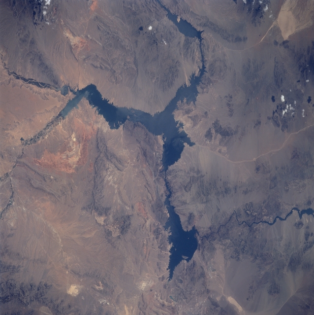 |
| STS090-739-036 Lake Mead, Nevada/Arizona, USA April 1998 The rugged desert landscape around Lake Mead is evident in this south looking view of southeastern Nevada and northwest Arizona. Numerous mountain ranges and cliffs, including Muddy Mountains (northwest of the lake), Black Mountains (along the eastern side of the Colorado River south of Hoover Dam), Virgin Mountains (northeast of lake), and the Grand Wash Cliffs (south of the lake), can be identified across the region. The Colorado River enters Lake Mead from the eastern side (left center) of the picture. Two distinct tributaries, the Virgin River from the north and the Meadow Valley Wash from the northwest, feed into the elongated, north-south arm of the lake. The Colorado River can be seen meandering south (forming the border between Arizona and Nevada) from the southwest section of Lake Mead after the river water passes through Hoover Dam (not detectable on this image). The light colored, linear features south of Lake Mead are washes (intermittent stream channels). The easternmost wash is connected to Red (Dry) Lake that can be seen in the southeast corner of the picture. Other lighter colored areas scattered across the desert terrain are also salt flats or dry lakebeds. |
| Images: | All Available Images Low-Resolution 300k |
|
| Mission: | STS090 |
|
| Roll - Frame: | 739 - 36 |
|
| Geographical Name: | USA-NEVADA |
|
| Features: | LAKE MEAD, LAS VEGAS |
|
| Center Lat x Lon: | 36.0N x 115.5W |
|
| Film Exposure: | N | N=Normal exposure, U=Under exposed, O=Over exposed, F=out of Focus |
| Percentage of Cloud Cover-CLDP: | 0 |
|
| Camera:: | HB |
|
| Camera Tilt: | 52 | LO=Low Oblique, HO=High Oblique, NV=Near Vertical |
| Camera Focal Length: | 250 |
|
| Nadir to Photo Center Direction: | S | The direction from the nadir to the center point, N=North, S=South, E=East, W=West |
| Stereo?: | Y | Y=Yes there is an adjacent picture of the same area, N=No there isn't |
| Orbit Number: | 162 |
|
| Date: | 19980427 | YYYYMMDD |
| Time: | 192455 | GMT HHMMSS |
| Nadir Lat: | 38.7N |
Latitude of suborbital point of spacecraft |
| Nadir Lon: | 114.6W |
Longitude of suborbital point of spacecraft |
| Sun Azimuth: | 174 | Clockwise angle in degrees from north to the sun measured at the nadir point |
| Space Craft Altitude: | 131 | nautical miles |
| Sun Elevation: | 65 | Angle in degrees between the horizon and the sun, measured at the nadir point |
| Land Views: | MOUNTAIN, DESERT |
|
| Water Views: | LAKE, RIVER, PLAYA |
|
| Atmosphere Views: | |
|
| Man Made Views: | |
|
| City Views: | |
|
Photo is not associated with any sequences | ||
| NASA Home Page |
JSC Home Page |
JSC Digital Image Collection |
Earth Science & Remote Sensing |
|
This service is provided by the International Space Station program and the JSC Earth Science & Remote Sensing Unit, ARES Division, Exploration Integration Science Directorate.

|