
Geographic Region: MEXICO
Feature: ACAPULCO
|
Geographic Region: MEXICO Feature: ACAPULCO |
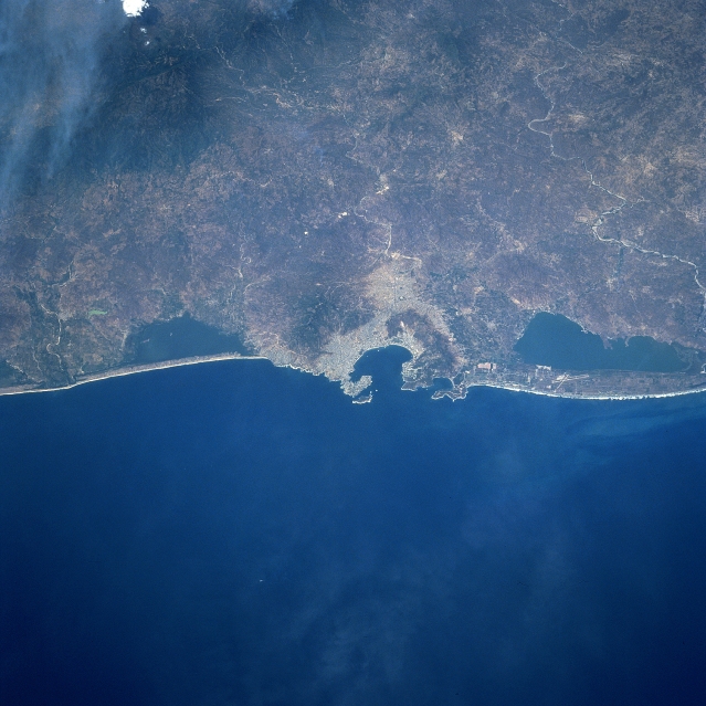 |
| STS090-732-076 Acapulco, Mexico April 1998 Near the center of the image, the international resort city of Acapulco and Acapulco Bay can be seen in this north-northeast-looking view. With the city's fine natural harbor, considered one of the best in Central America, Acapulco is a shipping point for the agricultural products of the region including cotton, fruit, and tobacco. The Bay of Acapulco is surrounded by cliffs and promontories and served as a base for the Colonial Spanish exploration of the Pacific. The port also served as the chief port for Spanish trade with the Philippines from 1565 to 1815. To the left or west of Acapulco, the Coyuca Lagoon is visible. Near the top left of the photo, smoke is visible from fires burning in the foothills of the Sierra Madre del Sur. To the right or southeast of Acapulco, the Tres Palos Lagoon is visible. On the corridor of land separating the Tres Palos Lagoon from the Pacific Ocean, the runways of the General Juan N. Alvarez International Airport are discernible. Acapulco has suffered frequent earthquake and hurricane damage. A hurricane in the late summer of 1997 caused severe flood damage to the city and the surrounding area due to excessive rains spawned by the storm. |
| Images: | All Available Images Low-Resolution 312k |
|
| Mission: | STS090 |
|
| Roll - Frame: | 732 - 76 |
|
| Geographical Name: | MEXICO |
|
| Features: | ACAPULCO |
|
| Center Lat x Lon: | 17.0N x 100W |
|
| Film Exposure: | N | N=Normal exposure, U=Under exposed, O=Over exposed, F=out of Focus |
| Percentage of Cloud Cover-CLDP: | 0 |
|
| Camera:: | HB |
|
| Camera Tilt: | 32 | LO=Low Oblique, HO=High Oblique, NV=Near Vertical |
| Camera Focal Length: | 250 |
|
| Nadir to Photo Center Direction: | NE | The direction from the nadir to the center point, N=North, S=South, E=East, W=West |
| Stereo?: | Y | Y=Yes there is an adjacent picture of the same area, N=No there isn't |
| Orbit Number: | 211 |
|
| Date: | 19980430 | YYYYMMDD |
| Time: | 205156 | GMT HHMMSS |
| Nadir Lat: | 15.8N |
Latitude of suborbital point of spacecraft |
| Nadir Lon: | 100.7W |
Longitude of suborbital point of spacecraft |
| Sun Azimuth: | 273 | Clockwise angle in degrees from north to the sun measured at the nadir point |
| Space Craft Altitude: | 134 | nautical miles |
| Sun Elevation: | 58 | Angle in degrees between the horizon and the sun, measured at the nadir point |
| Land Views: | COAST, MOUNTAIN |
|
| Water Views: | BAY, LAGOON, RIVER |
|
| Atmosphere Views: | |
|
| Man Made Views: | URBAN AREA, AIRPORT |
|
| City Views: | ACAPULCO |
|
Photo is not associated with any sequences | ||
| NASA Home Page |
JSC Home Page |
JSC Digital Image Collection |
Earth Science & Remote Sensing |
|
This service is provided by the International Space Station program and the JSC Earth Science & Remote Sensing Unit, ARES Division, Exploration Integration Science Directorate.

|