
Geographic Region: USA-TEXAS
Feature: SAN ANTONIO
|
Geographic Region: USA-TEXAS Feature: SAN ANTONIO |
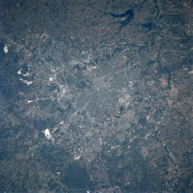 |
| STS090-732-073 San Antonio, Texas, USA April 1998 Downtown San Antonio, or the central business district (highly reflective area), is located near the center of the picture where numerous highways seemingly converge. Parts of the inner loop (Interstate Highway 410) and the outer beltway (Texas Highway 1604) are visible, as they partially encircle the built up urban area (mainly along the north side of San Antonio). The highly reflective white patches north of Texas Highway 1604 are areas where limestone has been quarried as aggregate for highway construction. Three reservoirs, (Calaveras, Brauning, and Mitchell) are visible (dark, irregular shaped features) southeast of downtown San Antonio. The linear runways of Randolph Air Force Base ("H" shape northeast of city), Kelley Air Force Base (southwest of city), and San Antonio International Airport (north of downtown) can be identified. The river channels, (Salada, San Antonio, and Leon Rivers) can be detected as meandering, dark features that eventually merge with the Medina River south of San Antonio. Cultivated field patterns are seen west and south of the city. |
| Images: | All Available Images Low-Resolution 378k |
|
| Mission: | STS090 |
|
| Roll - Frame: | 732 - 73 |
|
| Geographical Name: | USA-TEXAS |
|
| Features: | SAN ANTONIO |
|
| Center Lat x Lon: | 29.5N x 98.5W |
|
| Film Exposure: | N | N=Normal exposure, U=Under exposed, O=Over exposed, F=out of Focus |
| Percentage of Cloud Cover-CLDP: | 0 |
|
| Camera:: | HB |
|
| Camera Tilt: | 23 | LO=Low Oblique, HO=High Oblique, NV=Near Vertical |
| Camera Focal Length: | 250 |
|
| Nadir to Photo Center Direction: | E | The direction from the nadir to the center point, N=North, S=South, E=East, W=West |
| Stereo?: | Y | Y=Yes there is an adjacent picture of the same area, N=No there isn't |
| Orbit Number: | 210 |
|
| Date: | 19980430 | YYYYMMDD |
| Time: | 191602 | GMT HHMMSS |
| Nadir Lat: | 29.3N |
Latitude of suborbital point of spacecraft |
| Nadir Lon: | 99.4W |
Longitude of suborbital point of spacecraft |
| Sun Azimuth: | 216 | Clockwise angle in degrees from north to the sun measured at the nadir point |
| Space Craft Altitude: | 132 | nautical miles |
| Sun Elevation: | 73 | Angle in degrees between the horizon and the sun, measured at the nadir point |
| Land Views: | |
|
| Water Views: | RIVER, LAKE |
|
| Atmosphere Views: | |
|
| Man Made Views: | HIGHWAY, AIRPORT, URBAN AREA, MINING |
|
| City Views: | |
|
Photo is not associated with any sequences | ||
| NASA Home Page |
JSC Home Page |
JSC Digital Image Collection |
Earth Science & Remote Sensing |
|
This service is provided by the International Space Station program and the JSC Earth Science & Remote Sensing Unit, ARES Division, Exploration Integration Science Directorate.

|