
Geographic Region: USA-FLORIDA
Feature: TAMPA BAY,ST. PETERSBURG
|
Geographic Region: USA-FLORIDA Feature: TAMPA BAY,ST. PETERSBURG |
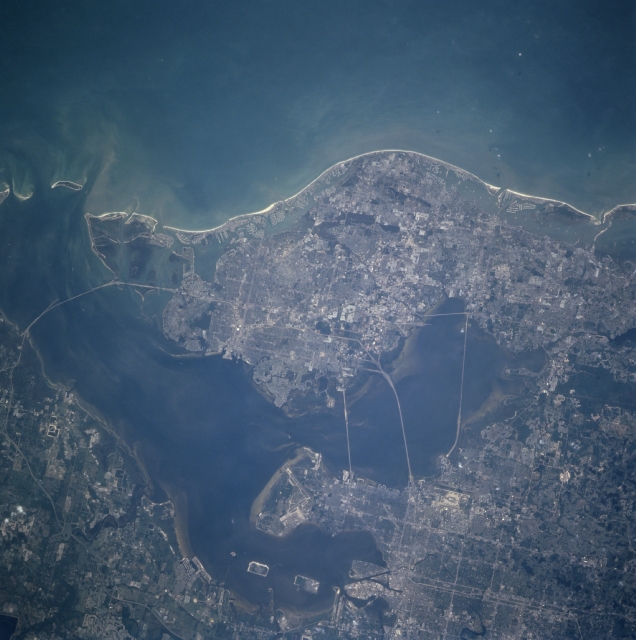 |
| STS090-726-047 Tampa Bay Area, Florida, USA April 1998 The intensively urbanized land that surrounds Tampa Bay stands out in this STS-90 photograph of the west central coast of Florida. The two bays north and northeast of Tampa Bay are Old Tampa Bay and Hillsborough Bay respectively. Several bridges (linear, light colored features) are visible connecting the three major cities of Clearwater (west side of photograph, adjacent to the Gulf of Mexico); St. Petersburg (southernmost city on the large peninsula); and Tampa (northeast quadrant of the picture). From north to south bridges in Tampa Bay include Courtney Campbell Causeway, Howard Franklin Bridge, Gandy Bridge, and the Sunshine Skyway Bridge. The runways of Macdill Air Force Base south of Tampa; Tampa International Airport along the east side of Old Tampa Bay and St. Petersburg-Clearwater International Airport along the west side of Old Tampa Bay, are discernible. |
| Images: | All Available Images Low-Resolution 291k |
|
| Mission: | STS090 |
|
| Roll - Frame: | 726 - 47 |
|
| Geographical Name: | USA-FLORIDA |
|
| Features: | TAMPA BAY,ST. PETERSBURG |
|
| Center Lat x Lon: | 28.0N x 82.5W |
|
| Film Exposure: | F | N=Normal exposure, U=Under exposed, O=Over exposed, F=out of Focus |
| Percentage of Cloud Cover-CLDP: | 0 |
|
| Camera:: | HB |
|
| Camera Tilt: | 12 | LO=Low Oblique, HO=High Oblique, NV=Near Vertical |
| Camera Focal Length: | 250 |
|
| Nadir to Photo Center Direction: | SW | The direction from the nadir to the center point, N=North, S=South, E=East, W=West |
| Stereo?: | N | Y=Yes there is an adjacent picture of the same area, N=No there isn't |
| Orbit Number: | 115 |
|
| Date: | 19980424 | YYYYMMDD |
| Time: | 211713 | GMT HHMMSS |
| Nadir Lat: | 28.4N |
Latitude of suborbital point of spacecraft |
| Nadir Lon: | 82.2W |
Longitude of suborbital point of spacecraft |
| Sun Azimuth: | 267 | Clockwise angle in degrees from north to the sun measured at the nadir point |
| Space Craft Altitude: | 138 | nautical miles |
| Sun Elevation: | 34 | Angle in degrees between the horizon and the sun, measured at the nadir point |
| Land Views: | COAST |
|
| Water Views: | BAY, GULF |
|
| Atmosphere Views: | |
|
| Man Made Views: | HIGHWAY, AIRPORT, URBAN AREA |
|
| City Views: | |
|
Photo is not associated with any sequences | ||
| NASA Home Page |
JSC Home Page |
JSC Digital Image Collection |
Earth Science & Remote Sensing |
|
This service is provided by the International Space Station program and the JSC Earth Science & Remote Sensing Unit, ARES Division, Exploration Integration Science Directorate.

|