
Geographic Region: USA-TEXAS
Feature: WACO, L. WACO, BRAZOS R.
|
Geographic Region: USA-TEXAS Feature: WACO, L. WACO, BRAZOS R. |
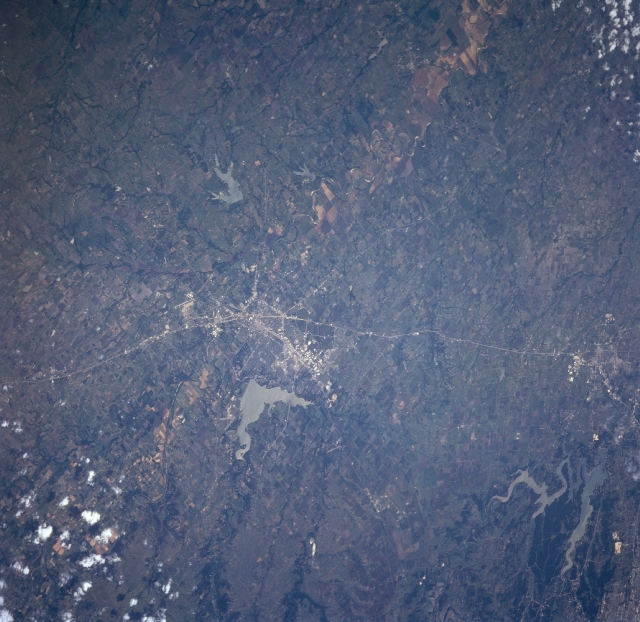 |
| STS090-721-076 Waco Area, Texas, USA April 1998 The view south along Interstate Highway 35 (thin, light-colored line) extends from north of Waco (cluster of light lines near center of image) to Temple, which is barely discernible at the top of the picture. Two large reservoirs, Lake Waco (immediately west of Waco) and much larger Belton Lake (upper right; irregular shape, lighter color) are clearly visible on the west side of the interstate highway. The V-shaped runways of Waco Airport can be seen along the north side of Lake Waco. The Brazos River flows southeastward and passes through downtown Waco. Southeast of the city the meandering Brazos River with its main channel, sand bars (whitish looking areas along the main channel), and an extensive floodplain is evident. Cultivated fields are visible in the fertile soils of the floodplain southeast of Waco. The hills to the west of Interstate Highway 35 are on the edge of the Comanche Plateau; while the flatter landscape east of the interstate highway is intermixed with trees and grasses of the Grand Prairie. |
| Images: | All Available Images Low-Resolution 335k |
|
| Mission: | STS090 |
|
| Roll - Frame: | 721 - 76 |
|
| Geographical Name: | USA-TEXAS |
|
| Features: | WACO, L. WACO, BRAZOS R. |
|
| Center Lat x Lon: | 31.5N x 97W |
|
| Film Exposure: | N | N=Normal exposure, U=Under exposed, O=Over exposed, F=out of Focus |
| Percentage of Cloud Cover-CLDP: | 5 |
|
| Camera:: | HB |
|
| Camera Tilt: | 41 | LO=Low Oblique, HO=High Oblique, NV=Near Vertical |
| Camera Focal Length: | 100 |
|
| Nadir to Photo Center Direction: | SW | The direction from the nadir to the center point, N=North, S=South, E=East, W=West |
| Stereo?: | Y | Y=Yes there is an adjacent picture of the same area, N=No there isn't |
| Orbit Number: | 178 |
|
| Date: | 19980428 | YYYYMMDD |
| Time: | 192450 | GMT HHMMSS |
| Nadir Lat: | 33.2N |
Latitude of suborbital point of spacecraft |
| Nadir Lon: | 96.1W |
Longitude of suborbital point of spacecraft |
| Sun Azimuth: | 221 | Clockwise angle in degrees from north to the sun measured at the nadir point |
| Space Craft Altitude: | 132 | nautical miles |
| Sun Elevation: | 66 | Angle in degrees between the horizon and the sun, measured at the nadir point |
| Land Views: | PLAIN, HILL, FLOOD PLAIN |
|
| Water Views: | LAKE, RIVER |
|
| Atmosphere Views: | |
|
| Man Made Views: | AIRPORT, HIGHWAY |
|
| City Views: | |
|
Photo is not associated with any sequences | ||
| NASA Home Page |
JSC Home Page |
JSC Digital Image Collection |
Earth Science & Remote Sensing |
|
This service is provided by the International Space Station program and the JSC Earth Science & Remote Sensing Unit, ARES Division, Exploration Integration Science Directorate.

|