
Geographic Region: USA-TEXAS
Feature: KILLEEN, BELTON, RES.
|
Geographic Region: USA-TEXAS Feature: KILLEEN, BELTON, RES. |
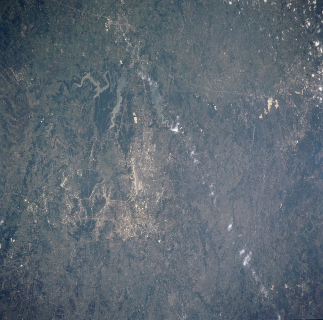 |
| STS090-721-072 Killeen, Fort Hood, Texas April 1998 The Temple/Killeen/Fort Hood area of central Texas can be seen in this south-looking view. Visible just to the right of the center of the image, Killeen is located in a ranching and cotton region just to the south of the Fort Hood Military Reservation. Fort Hood, covering an area of 340 square miles (881 sq. km) is the United States' largest military installation. The military base is host to the largest collection of soldiers and fighting machines in the free world. The United States Army post is the largest single location employer in the state of Texas. To the east of Killeen (near the left center of the image) is the city of Temple. Called the wildflower capital of Texas, Temple, 23 miles (37 km) east of Killeen/Fort Hood is located in a rich agricultural area of central Texas. Interstate Highway 35, a major transportation route between Dallas/Fort Worth and Austin/San Antonio passes through Temple. The highway can be seen entering the view near the bottom left of image (north), passing through the cities of Temple and Belton, and continuing on generally to the south 60 miles (97 km) reaching the northern portions of the city of Austin midway between the upper left and upper center of the image. Two lakes are visible on the image between Temple and Killeen/Fort Hood. The more northern lake just to the west of Temple is Stillhouse Hollow Lake with over 77 miles (124 km) of shoreline. Lake Belton can be seen to the south of Stillhouse Hollow Lake. Both lakes are known for their excellent fishing and recreational facilities. |
| Images: | All Available Images Low-Resolution 336k |
|
| Mission: | STS090 |
|
| Roll - Frame: | 721 - 72 |
|
| Geographical Name: | USA-TEXAS |
|
| Features: | KILLEEN, BELTON, RES. |
|
| Center Lat x Lon: | 31.0N x 98W |
|
| Film Exposure: | F | N=Normal exposure, U=Under exposed, O=Over exposed, F=out of Focus |
| Percentage of Cloud Cover-CLDP: | 5 |
|
| Camera:: | HB |
|
| Camera Tilt: | 51 | LO=Low Oblique, HO=High Oblique, NV=Near Vertical |
| Camera Focal Length: | 100 |
|
| Nadir to Photo Center Direction: | S | The direction from the nadir to the center point, N=North, S=South, E=East, W=West |
| Stereo?: | N | Y=Yes there is an adjacent picture of the same area, N=No there isn't |
| Orbit Number: | 178 |
|
| Date: | 19980428 | YYYYMMDD |
| Time: | 192438 | GMT HHMMSS |
| Nadir Lat: | 33.5N |
Latitude of suborbital point of spacecraft |
| Nadir Lon: | 97W |
Longitude of suborbital point of spacecraft |
| Sun Azimuth: | 219 | Clockwise angle in degrees from north to the sun measured at the nadir point |
| Space Craft Altitude: | 132 | nautical miles |
| Sun Elevation: | 67 | Angle in degrees between the horizon and the sun, measured at the nadir point |
| Land Views: | PLATEAU |
|
| Water Views: | LAKE |
|
| Atmosphere Views: | |
|
| Man Made Views: | URBAN AREA, HIGHWAY |
|
| City Views: | |
|
Photo is not associated with any sequences | ||
| NASA Home Page |
JSC Home Page |
JSC Digital Image Collection |
Earth Science & Remote Sensing |
|
This service is provided by the International Space Station program and the JSC Earth Science & Remote Sensing Unit, ARES Division, Exploration Integration Science Directorate.

|