
Geographic Region: KUWAIT
Feature: KUWAIT CITY, SHIP WAKES
|
Geographic Region: KUWAIT Feature: KUWAIT CITY, SHIP WAKES |
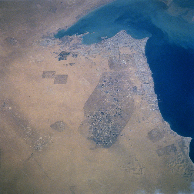 |
| STS090-719-042 Al Burqan Oil Field, Kuwait City, Kuwait April 1998 Nearly seven years after the end of the Gulf War, when the invading Iraqi troops seized Kuwait and set in motion their government's "scorched-earth" policy, the Al Burqan Oil Field, the world's largest oil and gas field, can be seen in this northeast-looking view. When this image was obtained, the oil field was back to producing at near capacity. Pools or lakes of oil (small dark spots) can still be seen scattered throughout the oil field. The lighter-colored, oil-less sands of the desert are discernible surrounding the large oil field. Smaller oil fields can also be seen scattered throughout the view. Refineries and large oil tanker docks are visible to the east of the Al Burqan Oil Field along the Persian Gulf Coast. Kuwait is mostly a flat sandy desert that gradually slopes downward from the west (left) towards sea level at the Persian Gulf. Dust storms are frequent during the summer months. Extremes of heat during the summer and cool to cold temperatures during the winter also characterize this region of the world. The capital of Kuwait, Kuwait City, is discernible with its many boulevards, to the north of the Al Burqan Oil Field. |
| Images: | All Available Images Low-Resolution 454k |
|
| Mission: | STS090 |
|
| Roll - Frame: | 719 - 42 |
|
| Geographical Name: | KUWAIT |
|
| Features: | KUWAIT CITY, SHIP WAKES |
|
| Center Lat x Lon: | 29.0N x 48.0E |
|
| Film Exposure: | N | N=Normal exposure, U=Under exposed, O=Over exposed, F=out of Focus |
| Percentage of Cloud Cover-CLDP: | 0 |
|
| Camera:: | HB |
|
| Camera Tilt: | 41 | LO=Low Oblique, HO=High Oblique, NV=Near Vertical |
| Camera Focal Length: | 250 |
|
| Nadir to Photo Center Direction: | N | The direction from the nadir to the center point, N=North, S=South, E=East, W=West |
| Stereo?: | Y | Y=Yes there is an adjacent picture of the same area, N=No there isn't |
| Orbit Number: | 188 |
|
| Date: | 19980429 | YYYYMMDD |
| Time: | 102454 | GMT HHMMSS |
| Nadir Lat: | 27.1N |
Latitude of suborbital point of spacecraft |
| Nadir Lon: | 48.4E |
Longitude of suborbital point of spacecraft |
| Sun Azimuth: | 247 | Clockwise angle in degrees from north to the sun measured at the nadir point |
| Space Craft Altitude: | 133 | nautical miles |
| Sun Elevation: | 63 | Angle in degrees between the horizon and the sun, measured at the nadir point |
| Land Views: | DESERT, PLAIN |
|
| Water Views: | GULF |
|
| Atmosphere Views: | SMOKE |
|
| Man Made Views: | URBAN AREA, HIGHWAY, AGRICULTURE, DRILLING |
|
| City Views: | |
|
Photo is not associated with any sequences | ||
| NASA Home Page |
JSC Home Page |
JSC Digital Image Collection |
Earth Science & Remote Sensing |
|
This service is provided by the International Space Station program and the JSC Earth Science & Remote Sensing Unit, ARES Division, Exploration Integration Science Directorate.

|