
Geographic Region: LESSER ANTILLES
Feature: ARUBA, SMOKE, GRANJESTAD
|
Geographic Region: LESSER ANTILLES Feature: ARUBA, SMOKE, GRANJESTAD |
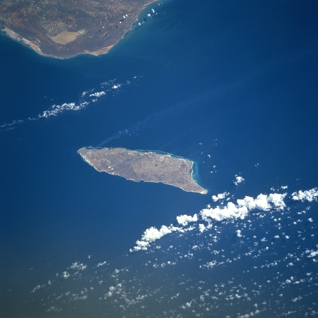 |
| STS090-716-00X Aruba, Netherland Antilles April 1998 The semi-arid island of Aruba can be seen in this south-looking view. Aruba is a semi-arid limestone platform set on an ancient core of igneous rock. The island is nearly 20 miles (32 km) long and up to 6 miles (10 km) wide and covers an area of 77 square miles (193 sq. km). Aruba is 19 miles (31 km) north of Cape San Roman on the Paraguana Peninsula (top left) of Venezuela. Little variation in temperatures occurs throughout the year and rainfall, which falls mostly in November and December, averages less than 20 inches (51 centimeters) a year. The red soil on the island is poor and thin and the thorny vegetation is quite drought resistant. Tourism and the refining of oil brought in from nearby Venezuela are the major industries. Oraniestad, located on the northwest coast, is the major city of the island. |
| Images: | All Available Images Low-Resolution 277k |
|
| Mission: | STS090 |
|
| Roll - Frame: | 716 - X |
|
| Geographical Name: | LESSER ANTILLES |
|
| Features: | ARUBA, SMOKE, GRANJESTAD |
|
| Center Lat x Lon: | 12.5N x 70W |
|
| Film Exposure: | N | N=Normal exposure, U=Under exposed, O=Over exposed, F=out of Focus |
| Percentage of Cloud Cover-CLDP: | 10 |
|
| Camera:: | HB |
|
| Camera Tilt: | NV | LO=Low Oblique, HO=High Oblique, NV=Near Vertical |
| Camera Focal Length: | 250 |
|
| Nadir to Photo Center Direction: | The direction from the nadir to the center point, N=North, S=South, E=East, W=West |
|
| Stereo?: | Y | Y=Yes there is an adjacent picture of the same area, N=No there isn't |
| Orbit Number: | |
|
| Date: | 1998____ | YYYYMMDD |
| Time: | GMT HHMMSS |
|
| Nadir Lat: | N |
Latitude of suborbital point of spacecraft |
| Nadir Lon: | E |
Longitude of suborbital point of spacecraft |
| Sun Azimuth: | Clockwise angle in degrees from north to the sun measured at the nadir point |
|
| Space Craft Altitude: | nautical miles |
|
| Sun Elevation: | Angle in degrees between the horizon and the sun, measured at the nadir point |
|
| Land Views: | ISLAND, COAST |
|
| Water Views: | SEA |
|
| Atmosphere Views: | PLUME |
|
| Man Made Views: | |
|
| City Views: | |
|
Photo is not associated with any sequences | ||
| NASA Home Page |
JSC Home Page |
JSC Digital Image Collection |
Earth Science & Remote Sensing |
|
This service is provided by the International Space Station program and the JSC Earth Science & Remote Sensing Unit, ARES Division, Exploration Integration Science Directorate.

|