
Geographic Region: ITALY
Feature: STRAIT OF MESSINA, WAKES
|
Geographic Region: ITALY Feature: STRAIT OF MESSINA, WAKES |
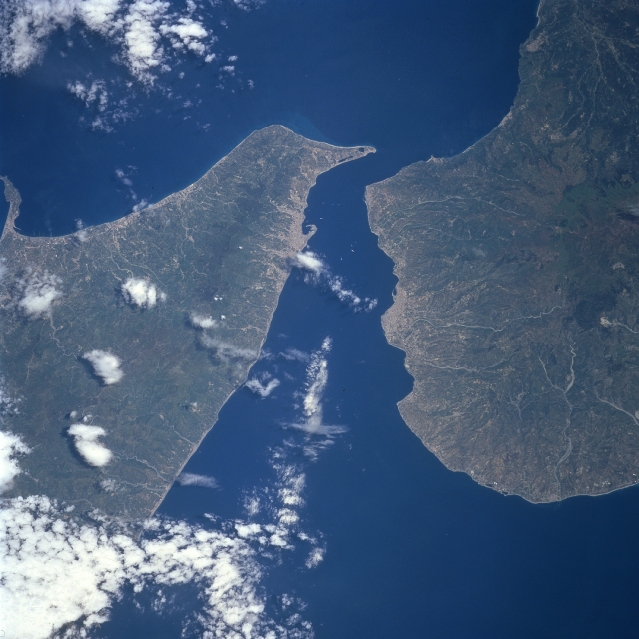 |
| STS090-715-060 Strait of Messina, Italy April 1998 The Strait of Messina separates Sicily (left-west) from the mainland of Italy (right-east) and also provides a water passage, connecting the Tyrrhenian Sea with the Ionian Sea. The strait measures 20 miles (32 km) in length and varies in width from 2 to 5 miles (3.2 to 8 km). The landscape on both sides of the strait is characterized by rugged mountainous terrain, short-flowing rivers, and clustered urban areas along the narrow coastline. The concentration of lighter colored areas along the shoreline identifies the location of Messina (Sicily) and Reggio di Calabria (Italy). The mountain ridges on either side of the strait exceed 4,000 feet (1,220 meters) above sea level. The pronounced radial drainage pattern of the mountainous area east of Reggio di Calabria indicates that this geologic structure is volcanic in origin. |
| Images: | All Available Images Low-Resolution 303k |
|
| Mission: | STS090 |
|
| Roll - Frame: | 715 - 60 |
|
| Geographical Name: | ITALY |
|
| Features: | STRAIT OF MESSINA, WAKES |
|
| Center Lat x Lon: | 38.0N x 15.5E |
|
| Film Exposure: | N | N=Normal exposure, U=Under exposed, O=Over exposed, F=out of Focus |
| Percentage of Cloud Cover-CLDP: | 5 |
|
| Camera:: | HB |
|
| Camera Tilt: | 25 | LO=Low Oblique, HO=High Oblique, NV=Near Vertical |
| Camera Focal Length: | 250 |
|
| Nadir to Photo Center Direction: | N | The direction from the nadir to the center point, N=North, S=South, E=East, W=West |
| Stereo?: | Y | Y=Yes there is an adjacent picture of the same area, N=No there isn't |
| Orbit Number: | 204 |
|
| Date: | 19980430 | YYYYMMDD |
| Time: | 101244 | GMT HHMMSS |
| Nadir Lat: | 37.0N |
Latitude of suborbital point of spacecraft |
| Nadir Lon: | 15.3E |
Longitude of suborbital point of spacecraft |
| Sun Azimuth: | 154 | Clockwise angle in degrees from north to the sun measured at the nadir point |
| Space Craft Altitude: | 131 | nautical miles |
| Sun Elevation: | 66 | Angle in degrees between the horizon and the sun, measured at the nadir point |
| Land Views: | MOUNTAIN |
|
| Water Views: | STRAIT |
|
| Atmosphere Views: | |
|
| Man Made Views: | |
|
| City Views: | |
|
Photo is not associated with any sequences | ||
| NASA Home Page |
JSC Home Page |
JSC Digital Image Collection |
Earth Science & Remote Sensing |
|
This service is provided by the International Space Station program and the JSC Earth Science & Remote Sensing Unit, ARES Division, Exploration Integration Science Directorate.

|