Geographic Region: SPAIN
Feature: GUADALQUIVIR DELTA,DUNES
|
Geographic Region: SPAIN Feature: GUADALQUIVIR DELTA,DUNES |
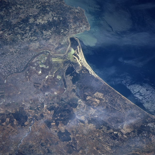 |
| STS090-714-047 Rio Guadaquivir, Spain April 1998 The linear but winding Rio Guadaquivir, helps identify this section of Spain's southwest coast that borders the Gulf of Cadiz. A variety of land use patterns are visible in this complex-looking landscape immediately southwest of Sevilla (just off the lower left edge of the image). Agricultural field patterns that occupy much of the landscape vary in size from large, angular shapes (probably wheat and barley fields) to small, mottled-looking patterns (fruit groves) primarily along the southeast side of the Rio Guadaquivir. This area of coastal plains, where water is available for irrigation, supports a variety of agricultural activities. Much of the area north of the river was at one time very swampy and undeveloped but reclamation efforts to transform the original marshlands into productive agricultural fields have been largely successful (although swampy areas still exist). In addition to the land use information about this image, some of the near shore water dynamics, including a sediment plume entering the Gulf of Cadre at the mouth of the Rio Guadaquivir can also be discerned. |
| Images: | All Available Images Low-Resolution 358k |
|
| Mission: | STS090 |
|
| Roll - Frame: | 714 - 47 |
|
| Geographical Name: | SPAIN |
|
| Features: | GUADALQUIVIR DELTA,DUNES |
|
| Center Lat x Lon: | 37.0N x 6.5W |
|
| Film Exposure: | N | N=Normal exposure, U=Under exposed, O=Over exposed, F=out of Focus |
| Percentage of Cloud Cover-CLDP: | 5 |
|
| Camera:: | HB |
|
| Camera Tilt: | LO | LO=Low Oblique, HO=High Oblique, NV=Near Vertical |
| Camera Focal Length: | 250 |
|
| Nadir to Photo Center Direction: | The direction from the nadir to the center point, N=North, S=South, E=East, W=West |
|
| Stereo?: | Y | Y=Yes there is an adjacent picture of the same area, N=No there isn't |
| Orbit Number: | |
|
| Date: | 1998____ | YYYYMMDD |
| Time: | GMT HHMMSS |
|
| Nadir Lat: | N |
Latitude of suborbital point of spacecraft |
| Nadir Lon: | E |
Longitude of suborbital point of spacecraft |
| Sun Azimuth: | Clockwise angle in degrees from north to the sun measured at the nadir point |
|
| Space Craft Altitude: | nautical miles |
|
| Sun Elevation: | Angle in degrees between the horizon and the sun, measured at the nadir point |
|
| Land Views: | COAST, PLAIN |
|
| Water Views: | RIVER, GULF, SEDIMENT |
|
| Atmosphere Views: | |
|
| Man Made Views: | |
|
| City Views: | |
|
Photo is not associated with any sequences | ||
| NASA Home Page |
JSC Home Page |
JSC Digital Image Collection |
Earth Science & Remote Sensing |
|
This service is provided by the International Space Station program and the JSC Earth Science & Remote Sensing Unit, ARES Division, Exploration Integration Science Directorate.

|