
Geographic Region: USA-VIRGINIA
Feature: NORKOLK, NEWPORT NEWS
|
Geographic Region: USA-VIRGINIA Feature: NORKOLK, NEWPORT NEWS |
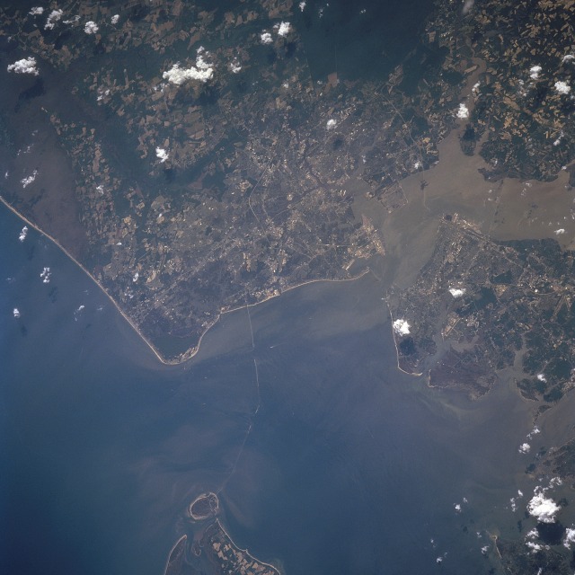 |
| STS090-712-058 Chesapeake Bay, Norfolk, Virginia April 1998 The entrance into Chesapeake Bay and the Norfolk Metropolitan area can be seen in this south-southwest-looking view. The southern tip of the Delmarva Peninsula and Cape Charles are visible near the bottom center of the image. The 18 mile (29 km) Chesapeake Bay Bridge-Tunnel complex traverses across Chesapeake Bay to just east of Norfolk. Cape Henry is visible to the bridge's east (left). Norfolk, Virginia's second largest city is bordered to the north by the Chesapeake Bay, to the northwest by Hampton Roads Harbor, and to the south-southwest by the Great Dismal Swamp (dark area towards the upper right). The city is the business, commercial, financial, cultural, and medical center of this region. Nearly two-thirds of the U.S. population lives within 750 miles (1208 km) of Norfolk. Norfolk's Harbor is called Hampton Roads and it is located where Chesapeake Bay, Elizabeth River, James River, and the Nansemond River meet. Hampton Roads is one of the largest, naturally deep, ice-free harbors in the world. The port traditionally handles more foreign waterborne commerce than any other United States port facility. Norfolk is also home to the largest Naval installation in the world. |
| Images: | All Available Images Low-Resolution 105k |
|
| Mission: | STS090 |
|
| Roll - Frame: | 712 - 58 |
|
| Geographical Name: | USA-VIRGINIA |
|
| Features: | NORKOLK, NEWPORT NEWS |
|
| Center Lat x Lon: | 37.0N x 76W |
|
| Film Exposure: | N | N=Normal exposure, U=Under exposed, O=Over exposed, F=out of Focus |
| Percentage of Cloud Cover-CLDP: | 5 |
|
| Camera:: | HB |
|
| Camera Tilt: | 36 | LO=Low Oblique, HO=High Oblique, NV=Near Vertical |
| Camera Focal Length: | 250 |
|
| Nadir to Photo Center Direction: | S | The direction from the nadir to the center point, N=North, S=South, E=East, W=West |
| Stereo?: | Y | Y=Yes there is an adjacent picture of the same area, N=No there isn't |
| Orbit Number: | 129 |
|
| Date: | 19980425 | YYYYMMDD |
| Time: | 180526 | GMT HHMMSS |
| Nadir Lat: | 38.5N |
Latitude of suborbital point of spacecraft |
| Nadir Lon: | 76.6W |
Longitude of suborbital point of spacecraft |
| Sun Azimuth: | 212 | Clockwise angle in degrees from north to the sun measured at the nadir point |
| Space Craft Altitude: | 133 | nautical miles |
| Sun Elevation: | 62 | Angle in degrees between the horizon and the sun, measured at the nadir point |
| Land Views: | CAPE, PLAIN, COAST |
|
| Water Views: | BAY, RIVER, SEDIMENT |
|
| Atmosphere Views: | |
|
| Man Made Views: | URBAN AREA |
|
| City Views: | NORFOLK |
|
Photo is not associated with any sequences | ||
| NASA Home Page |
JSC Home Page |
JSC Digital Image Collection |
Earth Science & Remote Sensing |
|
This service is provided by the International Space Station program and the JSC Earth Science & Remote Sensing Unit, ARES Division, Exploration Integration Science Directorate.

|