Geographic Region: CHINA
Feature: DALIAN,LUSHUN,JINZHOU B.
|
Geographic Region: CHINA Feature: DALIAN,LUSHUN,JINZHOU B. |
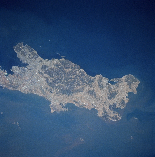 |
| STS090-707-074 Dalian (Dairen), China April 1998 The large city of Dalian (Dairen), visible at the left center of the image, is the leading port city of northeast China and China's second leading port behind Shanghai. Darian is located at the southern end of the Liaodong Peninsula. In this southeast-looking view, the many port facilities in Dalian Bay are discernible. With one of the finest harbors in East Asia, Dalian is a leading manufacturing, cultural, and financial center. The city is also a major tourist area with a mild climate and miles (km) of fine beaches. A major railroad transportation line connects with railroads in Manchuria to the north and eastern China to the west and south. Dalian has low mountains and hills on three sides of the city. |
| Images: | All Available Images Low-Resolution 305k |
|
| Mission: | STS090 |
|
| Roll - Frame: | 707 - 74 |
|
| Geographical Name: | CHINA |
|
| Features: | DALIAN,LUSHUN,JINZHOU B. |
|
| Center Lat x Lon: | 39.0N x 121.5E |
|
| Film Exposure: | N | N=Normal exposure, U=Under exposed, O=Over exposed, F=out of Focus |
| Percentage of Cloud Cover-CLDP: | 0 |
|
| Camera:: | HB |
|
| Camera Tilt: | 35 | LO=Low Oblique, HO=High Oblique, NV=Near Vertical |
| Camera Focal Length: | 100 |
|
| Nadir to Photo Center Direction: | N | The direction from the nadir to the center point, N=North, S=South, E=East, W=West |
| Stereo?: | Y | Y=Yes there is an adjacent picture of the same area, N=No there isn't |
| Orbit Number: | 119 |
|
| Date: | 19980425 | YYYYMMDD |
| Time: | 030203 | GMT HHMMSS |
| Nadir Lat: | 37.5N |
Latitude of suborbital point of spacecraft |
| Nadir Lon: | 122.0E |
Longitude of suborbital point of spacecraft |
| Sun Azimuth: | 153 | Clockwise angle in degrees from north to the sun measured at the nadir point |
| Space Craft Altitude: | 133 | nautical miles |
| Sun Elevation: | 63 | Angle in degrees between the horizon and the sun, measured at the nadir point |
| Land Views: | PENINSULA, MOUNTAIN, COAST |
|
| Water Views: | |
|
| Atmosphere Views: | |
|
| Man Made Views: | URBAN AREA, AIRPORT |
|
| City Views: | |
|
Photo is not associated with any sequences | ||
| NASA Home Page |
JSC Home Page |
JSC Digital Image Collection |
Earth Science & Remote Sensing |
|
This service is provided by the International Space Station program and the JSC Earth Science & Remote Sensing Unit, ARES Division, Exploration Integration Science Directorate.

|