
Geographic Region: USA-CALIFORNIA
Feature: SAN DIEGO, LAGUNA MTS.
|
Geographic Region: USA-CALIFORNIA Feature: SAN DIEGO, LAGUNA MTS. |
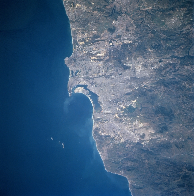 |
| STS090-705-093 San Diego Area, California, USA April 1998 The small scale of this image that includes San Diego (CA) and Tijuana (Mexico) allows the viewer to see the relationship of these two growing urban areas with regard to each other and also to the mountainous terrain south and east that effects their growth pattern. Three major colors in this picture reflect three distinct features: the lighter colored areas show the distribution of a human modified environment (urban, built-up); the darker land shows mountainous terrain (only sparsely populated); and the deep blue color of the Pacific Ocean. While it is difficult in general to identify specific urban infrastructure within these urban areas, segments of Interstate Highways 5, 8, and 15 are visible north, northeast of San Diego. San Diego Bay, the elongated, northwest-southeast oriented body of water is visible near the center of the image. The three small islands, Islas Coronados, off the coast belong to Mexico. |
| Images: | All Available Images Low-Resolution 321k |
|
| Mission: | STS090 |
|
| Roll - Frame: | 705 - 93 |
|
| Geographical Name: | USA-CALIFORNIA |
|
| Features: | SAN DIEGO, LAGUNA MTS. |
|
| Center Lat x Lon: | 32.5N x 117W |
|
| Film Exposure: | N | N=Normal exposure, U=Under exposed, O=Over exposed, F=out of Focus |
| Percentage of Cloud Cover-CLDP: | 0 |
|
| Camera:: | HB |
|
| Camera Tilt: | 46 | LO=Low Oblique, HO=High Oblique, NV=Near Vertical |
| Camera Focal Length: | 250 |
|
| Nadir to Photo Center Direction: | S | The direction from the nadir to the center point, N=North, S=South, E=East, W=West |
| Stereo?: | N | Y=Yes there is an adjacent picture of the same area, N=No there isn't |
| Orbit Number: | 19 |
|
| Date: | 19980418 | YYYYMMDD |
| Time: | 212359 | GMT HHMMSS |
| Nadir Lat: | 34.8N |
Latitude of suborbital point of spacecraft |
| Nadir Lon: | 117.6W |
Longitude of suborbital point of spacecraft |
| Sun Azimuth: | 228 | Clockwise angle in degrees from north to the sun measured at the nadir point |
| Space Craft Altitude: | 138 | nautical miles |
| Sun Elevation: | 58 | Angle in degrees between the horizon and the sun, measured at the nadir point |
| Land Views: | MOUNTAIN, COAST |
|
| Water Views: | BAY |
|
| Atmosphere Views: | |
|
| Man Made Views: | HIGHWAY |
|
| City Views: | |
|
Photo is not associated with any sequences | ||
| NASA Home Page |
JSC Home Page |
JSC Digital Image Collection |
Earth Science & Remote Sensing |
|
This service is provided by the International Space Station program and the JSC Earth Science & Remote Sensing Unit, ARES Division, Exploration Integration Science Directorate.

|