
Geographic Region: USA-CALIFORNIA
Feature: LOS ANGELES, STREETS
|
Geographic Region: USA-CALIFORNIA Feature: LOS ANGELES, STREETS |
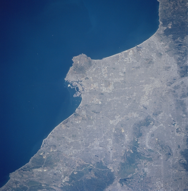 |
| STS090-705-087 Los Angeles Basin, California, USA April 1998 The central part of the Los Angeles Basin, including downtown Los Angeles and the greater Los Angeles metropolitan region, can be identified by the gridded street pattern in this near vertical image. Several of the many interstate highways (lighter colored, linear features) that cross this densely populated landscape are visible. Notice that dark mountain features restrict the growth of the cities. The Santa Ana Mountains (darker feature eastern edge of the image), and the Puente Hills (linear, darker feature northwest of Santa Ana Mountains) stand out in contrast against the light-colored highly reflective urban surfaces (buildings, aquaducts, highways, etc.). The clustered light colored areas within the large urban complex shows concentrated business, industrial, and commercial sites. The extensive harbor facilities, including Terminal Island, are visible near the center of the image just east of the Palos Verde Peninsula, the large peninsula that juts into the Pacific Ocean. |
| Images: | All Available Images Low-Resolution 303k |
|
| Mission: | STS090 |
|
| Roll - Frame: | 705 - 87 |
|
| Geographical Name: | USA-CALIFORNIA |
|
| Features: | LOS ANGELES, STREETS |
|
| Center Lat x Lon: | 34.0N x 118W |
|
| Film Exposure: | N | N=Normal exposure, U=Under exposed, O=Over exposed, F=out of Focus |
| Percentage of Cloud Cover-CLDP: | 0 |
|
| Camera:: | HB |
|
| Camera Tilt: | 50 | LO=Low Oblique, HO=High Oblique, NV=Near Vertical |
| Camera Focal Length: | 250 |
|
| Nadir to Photo Center Direction: | E | The direction from the nadir to the center point, N=North, S=South, E=East, W=West |
| Stereo?: | N | Y=Yes there is an adjacent picture of the same area, N=No there isn't |
| Orbit Number: | 19 |
|
| Date: | 19980418 | YYYYMMDD |
| Time: | 212316 | GMT HHMMSS |
| Nadir Lat: | 33.8N |
Latitude of suborbital point of spacecraft |
| Nadir Lon: | 120.7W |
Longitude of suborbital point of spacecraft |
| Sun Azimuth: | 224 | Clockwise angle in degrees from north to the sun measured at the nadir point |
| Space Craft Altitude: | 138 | nautical miles |
| Sun Elevation: | 61 | Angle in degrees between the horizon and the sun, measured at the nadir point |
| Land Views: | COAST, PENINSULA, MOUNTAIN |
|
| Water Views: | |
|
| Atmosphere Views: | |
|
| Man Made Views: | HIGHWAY, PORT |
|
| City Views: | |
|
Photo is not associated with any sequences | ||
| NASA Home Page |
JSC Home Page |
JSC Digital Image Collection |
Earth Science & Remote Sensing |
|
This service is provided by the International Space Station program and the JSC Earth Science & Remote Sensing Unit, ARES Division, Exploration Integration Science Directorate.

|