
Geographic Region: USA-CALIFORNIA
Feature: MONTEREY BAY, SALINAS
|
Geographic Region: USA-CALIFORNIA Feature: MONTEREY BAY, SALINAS |
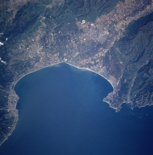 |
| STS090-705-005 Monterey Bay, California April, 1998 An inlet of the Pacific Ocean, Monterey Bay can be seen in this east-northeast-looking view. Once home of the nation's largest fishing port, Monterey Bay is today the largest marine sanctuary in the United States. Its diversity of habitats and marine life makes it one of the richest temperate-zone marine regions on Earth. This region is also home to the world's greatest assemblage of marine research institutions. In the upper right portion of the image and extending to Monterey Bay is the Salinas River Valley. Just below the center-left of the image is the city of Santa Cruz, a seaside city with many fine beaches that is backed by rugged hills and redwood forests. Midway between the center and right center of the image is the city of Monterey. Point Pinos to the north and Cypress Point to the south are also visible. At the right center of the image are the northern portions of the Santa Lucia Mountains. |
| Images: | All Available Images Low-Resolution 325k |
|
| Mission: | STS090 |
|
| Roll - Frame: | 705 - 5 |
|
| Geographical Name: | USA-CALIFORNIA |
|
| Features: | MONTEREY BAY, SALINAS |
|
| Center Lat x Lon: | 37.0N x 122W |
|
| Film Exposure: | N | N=Normal exposure, U=Under exposed, O=Over exposed, F=out of Focus |
| Percentage of Cloud Cover-CLDP: | 0 |
|
| Camera:: | HB |
|
| Camera Tilt: | 15 | LO=Low Oblique, HO=High Oblique, NV=Near Vertical |
| Camera Focal Length: | 250 |
|
| Nadir to Photo Center Direction: | S | The direction from the nadir to the center point, N=North, S=South, E=East, W=West |
| Stereo?: | Y | Y=Yes there is an adjacent picture of the same area, N=No there isn't |
| Orbit Number: | 4 |
|
| Date: | 19980417 | YYYYMMDD |
| Time: | 225937 | GMT HHMMSS |
| Nadir Lat: | 37.6N |
Latitude of suborbital point of spacecraft |
| Nadir Lon: | 122.1W |
Longitude of suborbital point of spacecraft |
| Sun Azimuth: | 247 | Clockwise angle in degrees from north to the sun measured at the nadir point |
| Space Craft Altitude: | 140 | nautical miles |
| Sun Elevation: | 43 | Angle in degrees between the horizon and the sun, measured at the nadir point |
| Land Views: | COAST, MOUNTAIN, VALLEY |
|
| Water Views: | BAY, RIVER |
|
| Atmosphere Views: | |
|
| Man Made Views: | URBAN AREA, AGRICULTURE |
|
| City Views: | |
|
Photo is not associated with any sequences | ||
| NASA Home Page |
JSC Home Page |
JSC Digital Image Collection |
Earth Science & Remote Sensing |
|
This service is provided by the International Space Station program and the JSC Earth Science & Remote Sensing Unit, ARES Division, Exploration Integration Science Directorate.

|