
Geographic Region: USA-CALIFORNIA
Feature: SAN FRANCISCO, OAKLAND
|
Geographic Region: USA-CALIFORNIA Feature: SAN FRANCISCO, OAKLAND |
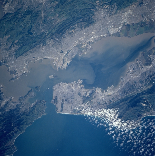 |
| STS090-705-004 San Francisco Bay Area, California April, 1998 Considered one of the best natural harbors in the world, San Francisco Bay, with its various sediment patterns, can be seen in this unique near-vertical view. Surrounded by the San Francisco Metropolitan area to the west and southwest, the Berkeley and Oakland Metropolitan area to the east, and the San Jose Metropolitan (not visible on the image) to the southeast, San Francisco Bay is 50 miles (80 km) long and from 3 to 13 miles (5 to 21 km) wide. Waters of the Pacific Ocean (bottom of image) enter the bay through Golden Gate, a strait between two peninsulas. The world famous Golden Gate Bridge is discernible on the image connecting the two peninsulas. The bay is as deep as 100 feet (30 meters) in spots, with a channel 50 feet (15 meters) deep maintained through the sand bar off Golden Gate. The major transportation routes in all metropolitan areas are visible on this image. Also discernible is the San Mateo Bridge near the right center of the image. Just to the left of the center of the image is Treasure Island, an artificial island covering 400 acres (162 hectares). It was constructed as a site of the Golden Gate International Exposition (1939-1940) and became a United States Naval Base in 1941. The small white objects in the bay and entering the golden gate are ships. |
| Images: | All Available Images Low-Resolution 348k |
|
| Mission: | STS090 |
|
| Roll - Frame: | 705 - 4 |
|
| Geographical Name: | USA-CALIFORNIA |
|
| Features: | SAN FRANCISCO, OAKLAND |
|
| Center Lat x Lon: | 37.5N x 122.5W |
|
| Film Exposure: | N | N=Normal exposure, U=Under exposed, O=Over exposed, F=out of Focus |
| Percentage of Cloud Cover-CLDP: | 10 |
|
| Camera:: | HB |
|
| Camera Tilt: | 2 | LO=Low Oblique, HO=High Oblique, NV=Near Vertical |
| Camera Focal Length: | 250 |
|
| Nadir to Photo Center Direction: | W | The direction from the nadir to the center point, N=North, S=South, E=East, W=West |
| Stereo?: | N | Y=Yes there is an adjacent picture of the same area, N=No there isn't |
| Orbit Number: | 4 |
|
| Date: | 19980417 | YYYYMMDD |
| Time: | 225934 | GMT HHMMSS |
| Nadir Lat: | 37.5N |
Latitude of suborbital point of spacecraft |
| Nadir Lon: | 122.4W |
Longitude of suborbital point of spacecraft |
| Sun Azimuth: | 246 | Clockwise angle in degrees from north to the sun measured at the nadir point |
| Space Craft Altitude: | 140 | nautical miles |
| Sun Elevation: | 43 | Angle in degrees between the horizon and the sun, measured at the nadir point |
| Land Views: | MOUNTAIN, FAULT |
|
| Water Views: | BAY, SEDIMENT |
|
| Atmosphere Views: | |
|
| Man Made Views: | URBAN AREA, AIRPORT |
|
| City Views: | SAN FRANCISCO, OAKLAND, BERKELEY |
|
Photo is not associated with any sequences | ||
| NASA Home Page |
JSC Home Page |
JSC Digital Image Collection |
Earth Science & Remote Sensing |
|
This service is provided by the International Space Station program and the JSC Earth Science & Remote Sensing Unit, ARES Division, Exploration Integration Science Directorate.

|