Geographic Region: FALKLAND ISLANDS
Feature: SOUTH GEORGIA ISLAND
|
Geographic Region: FALKLAND ISLANDS Feature: SOUTH GEORGIA ISLAND |
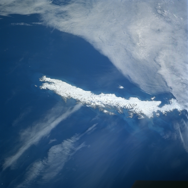 |
| STS089-717-025 South Georgia Island January 1998 At first glance South Georgia Island, elongated white colored feature in the center of the image appears to be some type of cloud formation. However, upon closer inspection the glacier covered island (slightly larger than the state of Rhode Island) is actually a continuation of the Andes Mountains that has a fjorded coastline with many large bays. The terrain of South Georgia Island is rugged and mountainous (many peaks exceed 6000 feet - 1829 meters above sea level) with steep, glacier-covered mountains running along the spine of the island. The maximum elevation near the center of the island is 9625 feet (2934 meters). The light colored sediment plumes seen at various locations around the island are the result of the glacial erosion process that has created these fine grained sediment plumes in the water. South Georgia Island continues to be administered from nearby Stanley in the Falkland Islands. Except for a small garrison of British soldiers, occasional tourists, and scientists, the harsh environment does not lend itself to permanent settlement. South Georgia Island is, however, one of the largest wildlife breeding areas in the southern Atlantic Ocean. The island is also home to a large colony of King Penguin (second largest species in the world after the Emperor penguins). |
| Images: | All Available Images Low-Resolution 247k |
|
| Mission: | STS089 |
|
| Roll - Frame: | 717 - 25 |
|
| Geographical Name: | FALKLAND ISLANDS |
|
| Features: | SOUTH GEORGIA ISLAND |
|
| Center Lat x Lon: | 54.5S x 36.5W |
|
| Film Exposure: | N | N=Normal exposure, U=Under exposed, O=Over exposed, F=out of Focus |
| Percentage of Cloud Cover-CLDP: | 50 |
|
| Camera:: | HB |
|
| Camera Tilt: | LO | LO=Low Oblique, HO=High Oblique, NV=Near Vertical |
| Camera Focal Length: | 100 |
|
| Nadir to Photo Center Direction: | W | The direction from the nadir to the center point, N=North, S=South, E=East, W=West |
| Stereo?: | Y | Y=Yes there is an adjacent picture of the same area, N=No there isn't |
| Orbit Number: | 70 |
|
| Date: | 19980127 | YYYYMMDD |
| Time: | 133329 | GMT HHMMSS |
| Nadir Lat: | 51.7S |
Latitude of suborbital point of spacecraft |
| Nadir Lon: | 28.3W |
Longitude of suborbital point of spacecraft |
| Sun Azimuth: | 14 | Clockwise angle in degrees from north to the sun measured at the nadir point |
| Space Craft Altitude: | 207 | nautical miles |
| Sun Elevation: | 56 | Angle in degrees between the horizon and the sun, measured at the nadir point |
| Land Views: | ISLAND, GLACIER |
|
| Water Views: | BAY, SEDIMENT |
|
| Atmosphere Views: | |
|
| Man Made Views: | |
|
| City Views: | |
|
Photo is not associated with any sequences | ||
| NASA Home Page |
JSC Home Page |
JSC Digital Image Collection |
Earth Science & Remote Sensing |
|
This service is provided by the International Space Station program and the JSC Earth Science & Remote Sensing Unit, ARES Division, Exploration Integration Science Directorate.

|