
Geographic Region: ARGENTINA
Feature: PLATA RIVER
|
Geographic Region: ARGENTINA Feature: PLATA RIVER |
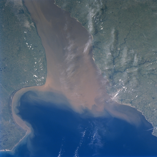 |
| STS089-709-056 Rio de la Plata, Uruguay January 1998 Although clouds obscure parts of the picture, the Rio de la Plata (a large estuary) is located between Argentina (south) and Uruguay (north). The estuary of the Rio de la Plata is one of the largest in the world. It receives runoff from five South American countries (Argentina, Uruguay, Brazil, Paraguay, and Bolivia). The extensive sediment plume (muddy looking water) in the Rio de la Plata seems to be a normal condition of the river. There is a constant mixing zone where the sediment-laden fresh water meets the salty waters of the southern Atlantic Ocean. Notice how a narrow band of sediment is hugging the U-shaped shoreline of the Argentina coast. The cluster of lighter colored areas near the top left corner of the image indicates the location of the city of La Plata and the eastern edge of the Argentine capital of Buenos Aires. The general location of the capital and largest city in Uruguay, Montevideo, can be identified along the northern shore of the estuary. The Santa Lucia River (dark, dendritic stream pattern) enters the Rio de la Plata just west of Montevideo. |
| Images: | All Available Images Low-Resolution 284k |
|
| Mission: | STS089 |
|
| Roll - Frame: | 709 - 56 |
|
| Geographical Name: | ARGENTINA |
|
| Features: | PLATA RIVER |
|
| Center Lat x Lon: | 35S x 57W |
|
| Film Exposure: | N | N=Normal exposure, U=Under exposed, O=Over exposed, F=out of Focus |
| Percentage of Cloud Cover-CLDP: | 5 |
|
| Camera:: | HB |
|
| Camera Tilt: | 28 | LO=Low Oblique, HO=High Oblique, NV=Near Vertical |
| Camera Focal Length: | 100 |
|
| Nadir to Photo Center Direction: | S | The direction from the nadir to the center point, N=North, S=South, E=East, W=West |
| Stereo?: | N | Y=Yes there is an adjacent picture of the same area, N=No there isn't |
| Orbit Number: | 120 |
|
| Date: | 19980130 | YYYYMMDD |
| Time: | 183012 | GMT HHMMSS |
| Nadir Lat: | 33.3S |
Latitude of suborbital point of spacecraft |
| Nadir Lon: | 57.4W |
Longitude of suborbital point of spacecraft |
| Sun Azimuth: | 286 | Clockwise angle in degrees from north to the sun measured at the nadir point |
| Space Craft Altitude: | 197 | nautical miles |
| Sun Elevation: | 54 | Angle in degrees between the horizon and the sun, measured at the nadir point |
| Land Views: | PLAIN |
|
| Water Views: | RIVER, SEDIMENT, ESTUARY |
|
| Atmosphere Views: | |
|
| Man Made Views: | |
|
| City Views: | |
|
Photo is not associated with any sequences | ||
| NASA Home Page |
JSC Home Page |
JSC Digital Image Collection |
Earth Science & Remote Sensing |
|
This service is provided by the International Space Station program and the JSC Earth Science & Remote Sensing Unit, ARES Division, Exploration Integration Science Directorate.

|