
Geographic Region: CHINA
Feature: P'O-MO LAKE
|
Geographic Region: CHINA Feature: P'O-MO LAKE |
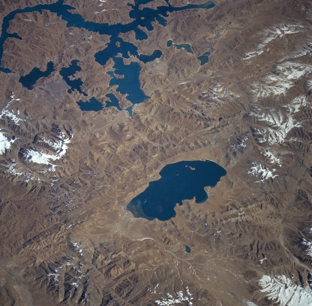 |
| STS087-720-062 Yamzho and Puma Lakes, China November 1997 Located on the southern Tibetan Plateau, two fairly large salt lakes are visible in this northeast-looking view. Near the center of the image is the almost rectangular-looking Puma Lake. Puma Lake is 20 miles (32 km) long, and is 8 miles (13 km) wide. Streams from the snow-capped surrounding mountains feed the lake, but the lake has no outlet. Some sediment can be seen entering the lake at its western end. In the upper left portion of the image is Yamzho Lake, which is over 45 miles (72 km) long. The lake is surrounded by many snow-capped mountains and is fed by numerous small streams. The lake does have an outlet stream at its far western end (not visible on the image). Yamzho Lake has a power station that was completed and dedicated in 1996 near the small village of Pai-Ti at the lake's western end. This power station is the largest in Tibet. |
| Images: | All Available Images Low-Resolution 379k |
|
| Mission: | STS087 |
|
| Roll - Frame: | 720 - 62 |
|
| Geographical Name: | CHINA |
|
| Features: | P'O-MO LAKE |
|
| Center Lat x Lon: | 28.5N x 90.5E |
|
| Film Exposure: | N | N=Normal exposure, U=Under exposed, O=Over exposed, F=out of Focus |
| Percentage of Cloud Cover-CLDP: | 0 |
|
| Camera:: | HB |
|
| Camera Tilt: | 52 | LO=Low Oblique, HO=High Oblique, NV=Near Vertical |
| Camera Focal Length: | 100 |
|
| Nadir to Photo Center Direction: | E | The direction from the nadir to the center point, N=North, S=South, E=East, W=West |
| Stereo?: | Y | Y=Yes there is an adjacent picture of the same area, N=No there isn't |
| Orbit Number: | 135 |
|
| Date: | 19971128 | YYYYMMDD |
| Time: | 044802 | GMT HHMMSS |
| Nadir Lat: | 27.9N |
Latitude of suborbital point of spacecraft |
| Nadir Lon: | 87.4E |
Longitude of suborbital point of spacecraft |
| Sun Azimuth: | 159 | Clockwise angle in degrees from north to the sun measured at the nadir point |
| Space Craft Altitude: | 150 | nautical miles |
| Sun Elevation: | 38 | Angle in degrees between the horizon and the sun, measured at the nadir point |
| Land Views: | MOUNTAIN, PLATEAU, FAULT |
|
| Water Views: | LAKE |
|
| Atmosphere Views: | |
|
| Man Made Views: | |
|
| City Views: | |
|
Photo is not associated with any sequences | ||
| NASA Home Page |
JSC Home Page |
JSC Digital Image Collection |
Earth Science & Remote Sensing |
|
This service is provided by the International Space Station program and the JSC Earth Science & Remote Sensing Unit, ARES Division, Exploration Integration Science Directorate.

|