
Geographic Region: PAKISTAN
Feature: KARACHI
|
Geographic Region: PAKISTAN Feature: KARACHI |
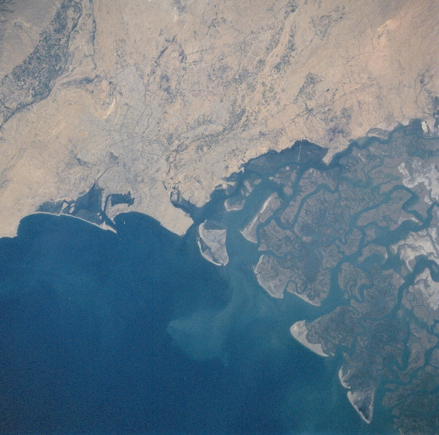 |
| STS087-715-70 Karachi, Pakistan November 1997 Karachi, the largest city and former capital (nearly 10 million people) of Pakistan, is located along the arid southern coast on the Arabian Sea. The central business district of Karachi is located close to the harbor (dark area enclosed by elongated island) where several roads converge (slightly right of center). Some of the road network (thin, dark lines) is discernible throughout different parts of the large metropolitan area. As seen on this image, Karachi is also situated northwest of the Indus River delta (darker land area upper left). The northwest end of the broad deltaic plain consists of a complicated network of meandering tidal channels. This section of the delta is inundated with salt water and sediment (a light colored sediment plume is visible immediately offshore). The small lighter colored tips of land along the shoreline shows the development of sandy beaches and sand dunes. |
| Images: | All Available Images Low-Resolution 348k |
|
| Mission: | STS087 |
|
| Roll - Frame: | 715 - 70 |
|
| Geographical Name: | PAKISTAN |
|
| Features: | KARACHI |
|
| Center Lat x Lon: | 25.0N x 67.0E |
|
| Film Exposure: | N | N=Normal exposure, U=Under exposed, O=Over exposed, F=out of Focus |
| Percentage of Cloud Cover-CLDP: | 10 |
|
| Camera:: | HB |
|
| Camera Tilt: | 16 | LO=Low Oblique, HO=High Oblique, NV=Near Vertical |
| Camera Focal Length: | 100 |
|
| Nadir to Photo Center Direction: | N | The direction from the nadir to the center point, N=North, S=South, E=East, W=West |
| Stereo?: | Y | Y=Yes there is an adjacent picture of the same area, N=No there isn't |
| Orbit Number: | 168 |
|
| Date: | 19971130 | YYYYMMDD |
| Time: | 062049 | GMT HHMMSS |
| Nadir Lat: | 24.3N |
Latitude of suborbital point of spacecraft |
| Nadir Lon: | 67.0E |
Longitude of suborbital point of spacecraft |
| Sun Azimuth: | 161 | Clockwise angle in degrees from north to the sun measured at the nadir point |
| Space Craft Altitude: | 150 | nautical miles |
| Sun Elevation: | 42 | Angle in degrees between the horizon and the sun, measured at the nadir point |
| Land Views: | PLAIN |
|
| Water Views: | RIVER, DELTA |
|
| Atmosphere Views: | |
|
| Man Made Views: | URBAN AREA, HIGHWAY |
|
| City Views: | |
|
Photo is not associated with any sequences | ||
| NASA Home Page |
JSC Home Page |
JSC Digital Image Collection |
Earth Science & Remote Sensing |
|
This service is provided by the International Space Station program and the JSC Earth Science & Remote Sensing Unit, ARES Division, Exploration Integration Science Directorate.

|