
Geographic Region: CHINA
Feature: YAMZHO LAKE
|
Geographic Region: CHINA Feature: YAMZHO LAKE |
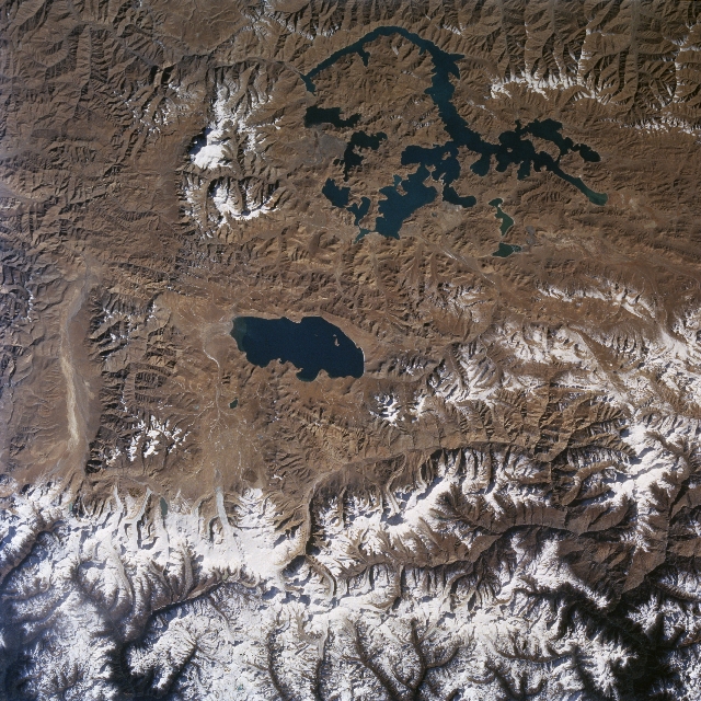 |
| STS087-713-001 Tibetan Lakes, China November 1997 Two distinct lakes (dark features) are clearly visible in this barren, elevated landscape of the Tibetan Plateau north of Bhutan. The surface elevation of the compact-looking lake near the center of the image, Puma Yumco Lake, is 16525 feet (5037 meters) above sea level; while the surface elevation of Yamzho Yumco Lake with its more elongated and complex pattern is 14700 feet (4480 meters). This section of the Chinese Tibetan Plateau is a rugged, sparsely vegetated plateau with practically all of the terrain in this image above 15000 feet (4572 meters) above sea level. An indefinite border that exists between Bhutan (south) and China (north) extends generally east to west across the higher elevations of the snow and ice (glaciers) Himalaya Mountains (bottom). Several peaks in these permanently glaciated mountains exceed 23000 feet (7010 meters). Numerous glaciated river valleys (dark drainage pattern bottom edge) drain southward through northern Bhutan. |
| Images: | All Available Images Low-Resolution 423k |
|
| Mission: | STS087 |
|
| Roll - Frame: | 713 - 1 |
|
| Geographical Name: | CHINA |
|
| Features: | YAMZHO LAKE |
|
| Center Lat x Lon: | 28.5N x 90.5E |
|
| Film Exposure: | N | N=Normal exposure, U=Under exposed, O=Over exposed, F=out of Focus |
| Percentage of Cloud Cover-CLDP: | 0 |
|
| Camera:: | HB |
|
| Camera Tilt: | 22 | LO=Low Oblique, HO=High Oblique, NV=Near Vertical |
| Camera Focal Length: | 50 |
|
| Nadir to Photo Center Direction: | E | The direction from the nadir to the center point, N=North, S=South, E=East, W=West |
| Stereo?: | Y | Y=Yes there is an adjacent picture of the same area, N=No there isn't |
| Orbit Number: | 150 |
|
| Date: | 19971129 | YYYYMMDD |
| Time: | 031417 | GMT HHMMSS |
| Nadir Lat: | 28.6N |
Latitude of suborbital point of spacecraft |
| Nadir Lon: | 89.5E |
Longitude of suborbital point of spacecraft |
| Sun Azimuth: | 139 | Clockwise angle in degrees from north to the sun measured at the nadir point |
| Space Craft Altitude: | 149 | nautical miles |
| Sun Elevation: | 27 | Angle in degrees between the horizon and the sun, measured at the nadir point |
| Land Views: | PLATEAU, MOUNTAIN |
|
| Water Views: | LAKE |
|
| Atmosphere Views: | |
|
| Man Made Views: | |
|
| City Views: | |
|
Photo is not associated with any sequences | ||
| NASA Home Page |
JSC Home Page |
JSC Digital Image Collection |
Earth Science & Remote Sensing |
|
This service is provided by the International Space Station program and the JSC Earth Science & Remote Sensing Unit, ARES Division, Exploration Integration Science Directorate.

|