Geographic Region: INDIA
Feature: MAHANDI RIVER
|
Geographic Region: INDIA Feature: MAHANDI RIVER |
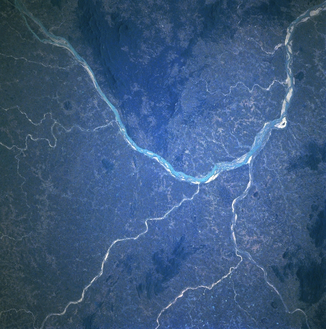 |
| STS087-707-060 Mahanadi River, India November 1997 The Mahanadi River (light-colored linear feature), largest river in Orissi State, makes a dramatic south to east course change immediately to the south of Hirakud Dam and Reservoir (just off of lower right corner of the image). The highly reflective material within the floodplain of the Mahanadi River as well as the tributary streams, are extensive sandbars that become more visible, especially during periods of low water (November through May/June). The darker area on the image shows the distribution of hilly, wooded terrain. The darkest areas in this region of east central India have elevations that exceed 2000 feet (610 meters) above sea level. |
| Images: | All Available Images Low-Resolution 372k |
|
| Mission: | STS087 |
|
| Roll - Frame: | 707 - 60 |
|
| Geographical Name: | INDIA |
|
| Features: | MAHANDI RIVER |
|
| Center Lat x Lon: | 21.0N x 84.0E |
|
| Film Exposure: | N | N=Normal exposure, U=Under exposed, O=Over exposed, F=out of Focus |
| Percentage of Cloud Cover-CLDP: | 0 |
|
| Camera:: | HB |
|
| Camera Tilt: | 26 | LO=Low Oblique, HO=High Oblique, NV=Near Vertical |
| Camera Focal Length: | 250 |
|
| Nadir to Photo Center Direction: | E | The direction from the nadir to the center point, N=North, S=South, E=East, W=West |
| Stereo?: | Y | Y=Yes there is an adjacent picture of the same area, N=No there isn't |
| Orbit Number: | 39 |
|
| Date: | 19971122 | YYYYMMDD |
| Time: | 044014 | GMT HHMMSS |
| Nadir Lat: | 21.5N |
Latitude of suborbital point of spacecraft |
| Nadir Lon: | 82.9E |
Longitude of suborbital point of spacecraft |
| Sun Azimuth: | 149 | Clockwise angle in degrees from north to the sun measured at the nadir point |
| Space Craft Altitude: | 150 | nautical miles |
| Sun Elevation: | 43 | Angle in degrees between the horizon and the sun, measured at the nadir point |
| Land Views: | PLAIN, HILL |
|
| Water Views: | RIVER |
|
| Atmosphere Views: | |
|
| Man Made Views: | |
|
| City Views: | |
|
Photo is not associated with any sequences | ||
| NASA Home Page |
JSC Home Page |
JSC Digital Image Collection |
Earth Science & Remote Sensing |
|
This service is provided by the International Space Station program and the JSC Earth Science & Remote Sensing Unit, ARES Division, Exploration Integration Science Directorate.

|