
Geographic Region: MEXICO
Feature: SIERRA MADRE ORIENTAL
|
Geographic Region: MEXICO Feature: SIERRA MADRE ORIENTAL |
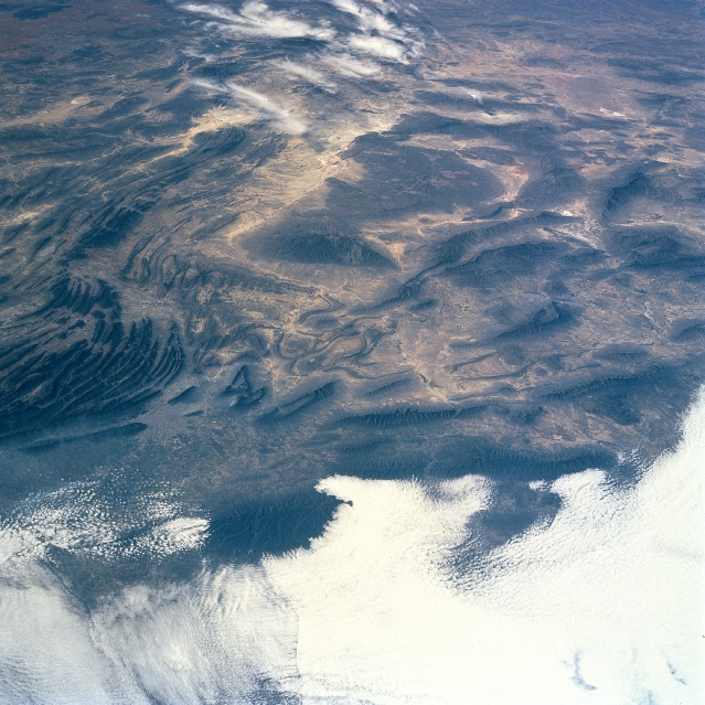 |
| STS087-706-5 Sierra Madre Oriental, Mexico November 1997 The folded, rugged, Sierra Madre Oriental (eastern), a southern extension of the Rocky Mountains of the United States and Canada, can be seen in this west-northwest view. The Sierra Madre Oriental is the boundary of the dissected eastern edge of the High Mexican Central Plateau and the Gulf coastal plain. Beginning as barren hills south of the Rio Grande in northeastern Mexico, the Sierra Madre Oriental extend generally southward approximately 700 miles (1125 km), to near 19 degrees north latitude paralleling the coast of the western Gulf of Mexico. The average elevation of the mountain range is 7000 feet (2135 meters) with some peaks exceeding 10000 feet (3050 meters). A wealth of minerals including iron ore, lead, silver, and gold, are extracted from the mountain range. The city of Monterey, Mexico is discernible just inward toward the center from the left center of the image. Clouds cover the coastal plain in the bottom third of the image. |
| Images: | All Available Images Low-Resolution 367k |
|
| Mission: | STS087 |
|
| Roll - Frame: | 706 - 5 |
|
| Geographical Name: | MEXICO |
|
| Features: | SIERRA MADRE ORIENTAL |
|
| Center Lat x Lon: | 26.0N x 100W |
|
| Film Exposure: | N | N=Normal exposure, U=Under exposed, O=Over exposed, F=out of Focus |
| Percentage of Cloud Cover-CLDP: | 25 |
|
| Camera:: | HB |
|
| Camera Tilt: | 38 | LO=Low Oblique, HO=High Oblique, NV=Near Vertical |
| Camera Focal Length: | 100 |
|
| Nadir to Photo Center Direction: | W | The direction from the nadir to the center point, N=North, S=South, E=East, W=West |
| Stereo?: | Y | Y=Yes there is an adjacent picture of the same area, N=No there isn't |
| Orbit Number: | 32 |
|
| Date: | 19971121 | YYYYMMDD |
| Time: | 181505 | GMT HHMMSS |
| Nadir Lat: | 26.3N |
Latitude of suborbital point of spacecraft |
| Nadir Lon: | 98.1W |
Longitude of suborbital point of spacecraft |
| Sun Azimuth: | 179 | Clockwise angle in degrees from north to the sun measured at the nadir point |
| Space Craft Altitude: | 150 | nautical miles |
| Sun Elevation: | 44 | Angle in degrees between the horizon and the sun, measured at the nadir point |
| Land Views: | MOUNTAIN, FAULT, UPLAND, ESCARPMENT |
|
| Water Views: | |
|
| Atmosphere Views: | |
|
| Man Made Views: | |
|
| City Views: | |
|
Photo is not associated with any sequences | ||
| NASA Home Page |
JSC Home Page |
JSC Digital Image Collection |
Earth Science & Remote Sensing |
|
This service is provided by the International Space Station program and the JSC Earth Science & Remote Sensing Unit, ARES Division, Exploration Integration Science Directorate.

|