
Geographic Region: PAKISTAN
Feature: SALT FLAT
|
Geographic Region: PAKISTAN Feature: SALT FLAT |
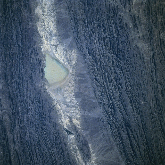 |
| STS087-702-23 Kolwa Valley, Pakistan November 1997 The paralleling and tilted rock beds of the Central Makran Mountains flank one of many arid valleys in southwest Pakistan. This particular valley, known as the Kolwa Valley, includes a sizeable dry lake (highly reflective surface near center) that extends in a gentle arc from northeast to southwest. The valley was named for a small village that is situated near the southwest end of the valley. The folded mountains and valleys shown in this image are the result of tremendous tectonic forces, created by the Indian Plate colliding with the more massive Eurasian Plate. The alternating light and dark linear features that radiate into the valley from the surrounding rugged hills and low mountains are alluvial deposits that have formed along the flanks of the low mountainous relief. The small dark spots within the valley show the location and distribution of limited agricultural activity where adequate moisture permits. |
| Images: | All Available Images Low-Resolution 396k |
|
| Mission: | STS087 |
|
| Roll - Frame: | 702 - 23 |
|
| Geographical Name: | PAKISTAN |
|
| Features: | SALT FLAT |
|
| Center Lat x Lon: | 26.0N x 64.5E |
|
| Film Exposure: | N | N=Normal exposure, U=Under exposed, O=Over exposed, F=out of Focus |
| Percentage of Cloud Cover-CLDP: | 0 |
|
| Camera:: | HB |
|
| Camera Tilt: | 27 | LO=Low Oblique, HO=High Oblique, NV=Near Vertical |
| Camera Focal Length: | 100 |
|
| Nadir to Photo Center Direction: | S | The direction from the nadir to the center point, N=North, S=South, E=East, W=West |
| Stereo?: | Y | Y=Yes there is an adjacent picture of the same area, N=No there isn't |
| Orbit Number: | 119 |
|
| Date: | 19971127 | YYYYMMDD |
| Time: | 044109 | GMT HHMMSS |
| Nadir Lat: | 27.2N |
Latitude of suborbital point of spacecraft |
| Nadir Lon: | 64.1E |
Longitude of suborbital point of spacecraft |
| Sun Azimuth: | 135 | Clockwise angle in degrees from north to the sun measured at the nadir point |
| Space Craft Altitude: | 150 | nautical miles |
| Sun Elevation: | 27 | Angle in degrees between the horizon and the sun, measured at the nadir point |
| Land Views: | MOUNTAIN, VALLEY |
|
| Water Views: | PLAYA |
|
| Atmosphere Views: | |
|
| Man Made Views: | |
|
| City Views: | |
|
Photo is not associated with any sequences | ||
| NASA Home Page |
JSC Home Page |
JSC Digital Image Collection |
Earth Science & Remote Sensing |
|
This service is provided by the International Space Station program and the JSC Earth Science & Remote Sensing Unit, ARES Division, Exploration Integration Science Directorate.

|